You are here: Home > Network List > AZ - ANZA Regional Network Stations List
> Station SMER AZ.SMER > Earthquake Result Viewer
SMER AZ.SMER - Earthquake Result Viewer
| Earthquake location: |
Tonga Islands Region |
| Earthquake latitude/longitude: |
-19.3/-172.1 |
| Earthquake time(UTC): |
2022/11/11 (315) 10:48:45 GMT |
| Earthquake Depth: |
25 km |
| Earthquake Magnitude: |
7.3 Mww |
| Earthquake Catalog/Contributor: |
NEIC PDE/us |
|
| Network: |
AZ ANZA Regional Network |
| Station: |
SMER AZ.SMER |
| Lat/Lon: |
33.46 N/117.17 W |
| Elevation: |
355 m |
|
| Distance: |
74.1 deg |
| Az: |
45.338 deg |
| Baz: |
233.465 deg |
| Ray Param: |
0.052513458 |
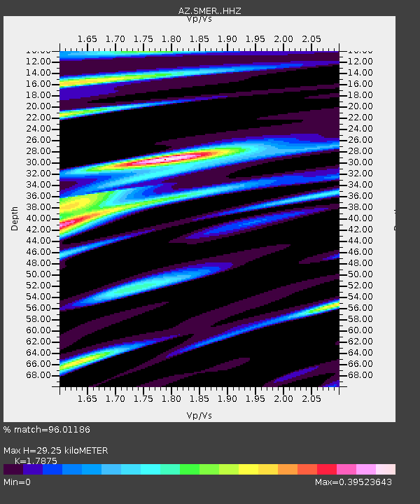
| Estimated Moho Depth: |
29.25 km |
| Estimated Crust Vp/Vs: |
1.79 |
| Assumed Crust Vp: |
6.264 km/s |
| Estimated Crust Vs: |
3.504 km/s |
| Estimated Crust Poisson's Ratio: |
0.27 |
|
| Radial Match: |
96.01186 % |
| Radial Bump: |
220 |
| Transverse Match: |
90.20093 % |
| Transverse Bump: |
383 |
| SOD ConfigId: |
29756493 |
| Insert Time: |
2022-11-25 11:00:09.696 +0000 |
| GWidth: |
2.5 |
| Max Bumps: |
400 |
| Tol: |
0.001 |
|
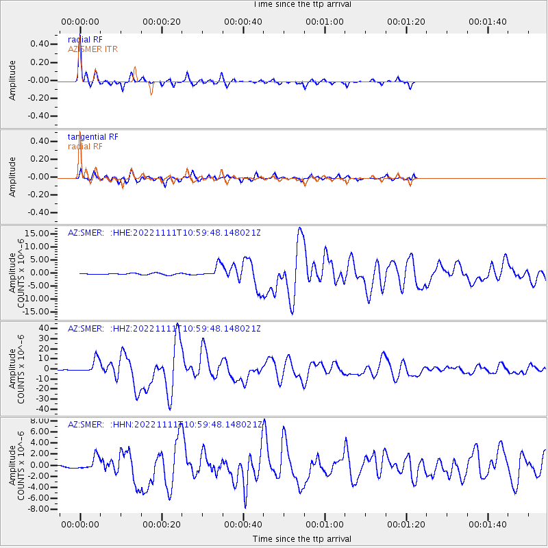
Signal To Noise
| Channel | StoN | STA | LTA |
| AZ:SMER: :HHZ:20221111T10:59:48.148021Z | 29.102777 | 7.4311815E-6 | 2.5534268E-7 |
| AZ:SMER: :HHN:20221111T10:59:48.148021Z | 2.8743644 | 1.1956502E-6 | 4.159703E-7 |
| AZ:SMER: :HHE:20221111T10:59:48.148021Z | 9.069524 | 2.4897058E-6 | 2.7451338E-7 |
| Arrivals |
| Ps | 3.8 SECOND |
| PpPs | 13 SECOND |
| PsPs/PpSs | 16 SECOND |


