You are here: Home > Network List > BK - Berkeley Digital Seismograph Network Stations List
> Station MCCM Marconi Conference Center, Marshall, CA, USA > Earthquake Result Viewer
MCCM Marconi Conference Center, Marshall, CA, USA - Earthquake Result Viewer
| Earthquake location: |
Tonga Islands Region |
| Earthquake latitude/longitude: |
-19.3/-172.1 |
| Earthquake time(UTC): |
2022/11/11 (315) 10:48:45 GMT |
| Earthquake Depth: |
25 km |
| Earthquake Magnitude: |
7.3 Mww |
| Earthquake Catalog/Contributor: |
NEIC PDE/us |
|
| Network: |
BK Berkeley Digital Seismograph Network |
| Station: |
MCCM Marconi Conference Center, Marshall, CA, USA |
| Lat/Lon: |
38.14 N/122.88 W |
| Elevation: |
-7.7 m |
|
| Distance: |
73.5 deg |
| Az: |
38.513 deg |
| Baz: |
228.231 deg |
| Ray Param: |
0.052938018 |
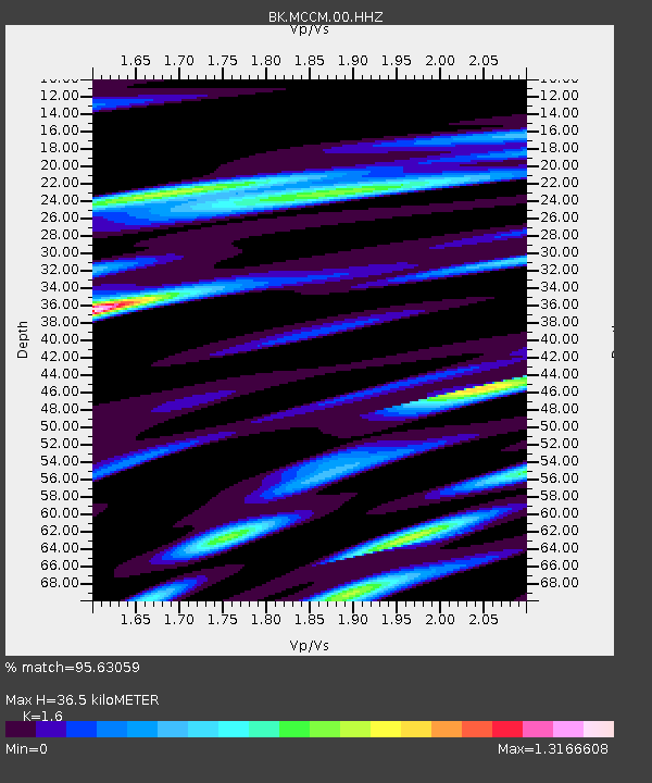
| Estimated Moho Depth: |
36.5 km |
| Estimated Crust Vp/Vs: |
1.60 |
| Assumed Crust Vp: |
6.472 km/s |
| Estimated Crust Vs: |
4.045 km/s |
| Estimated Crust Poisson's Ratio: |
0.18 |
|
| Radial Match: |
95.63059 % |
| Radial Bump: |
400 |
| Transverse Match: |
86.82295 % |
| Transverse Bump: |
400 |
| SOD ConfigId: |
29756493 |
| Insert Time: |
2022-11-25 11:01:01.265 +0000 |
| GWidth: |
2.5 |
| Max Bumps: |
400 |
| Tol: |
0.001 |
|
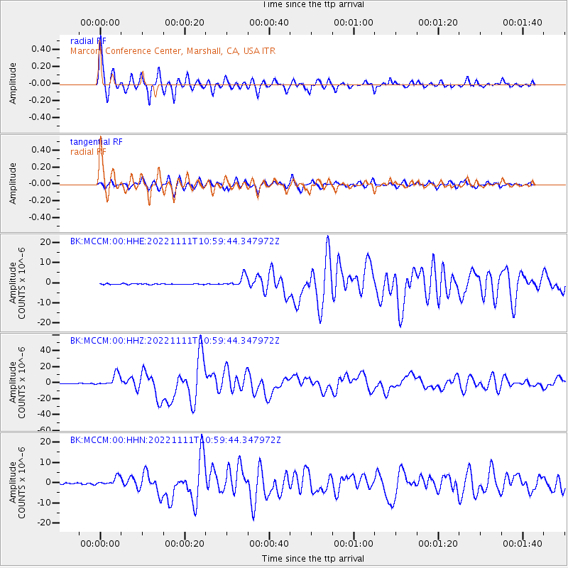
Signal To Noise
| Channel | StoN | STA | LTA |
| BK:MCCM:00:HHZ:20221111T10:59:44.347972Z | 32.677784 | 7.996033E-6 | 2.4469327E-7 |
| BK:MCCM:00:HHN:20221111T10:59:44.347972Z | 7.84579 | 2.20839E-6 | 2.8147454E-7 |
| BK:MCCM:00:HHE:20221111T10:59:44.347972Z | 14.030859 | 2.7971012E-6 | 1.9935352E-7 |
| Arrivals |
| Ps | 3.5 SECOND |
| PpPs | 14 SECOND |
| PsPs/PpSs | 18 SECOND |


