You are here: Home > Network List > C0 - Colorado Geological Survey Seismic Network Stations List
> Station HAYD Hayden Colorado > Earthquake Result Viewer
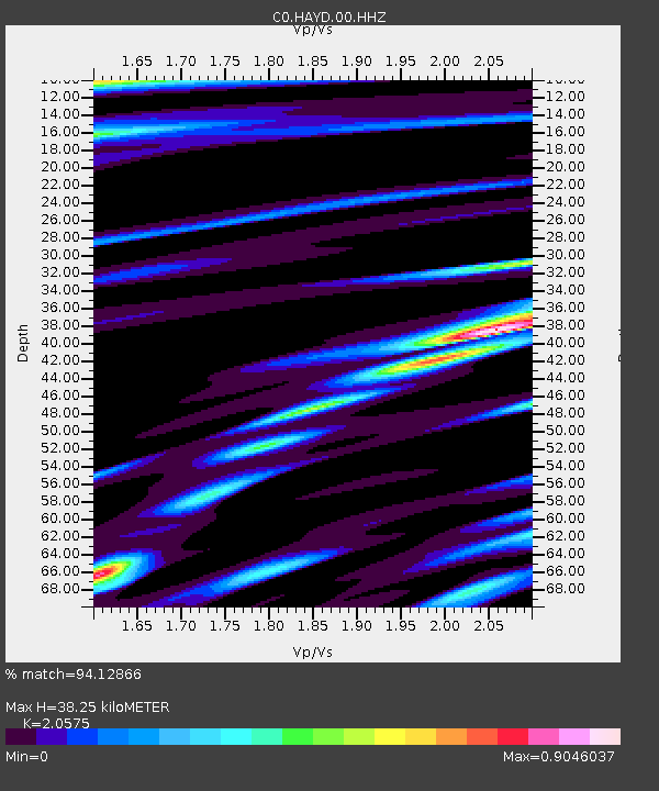
HAYD Hayden Colorado - Earthquake Result Viewer
| Earthquake location: |
Tonga Islands Region |
| Earthquake latitude/longitude: |
-19.3/-172.1 |
| Earthquake time(UTC): |
2022/11/11 (315) 10:48:45 GMT |
| Earthquake Depth: |
25 km |
| Earthquake Magnitude: |
7.3 Mww |
| Earthquake Catalog/Contributor: |
NEIC PDE/us |
|
| Network: |
C0 Colorado Geological Survey Seismic Network |
| Station: |
HAYD Hayden Colorado |
| Lat/Lon: |
40.53 N/107.27 W |
| Elevation: |
2202 m |
|
| Distance: |
84.6 deg |
| Az: |
43.861 deg |
| Baz: |
239.147 deg |
| Ray Param: |
0.045309357 |
| Estimated Moho Depth: |
38.25 km |
| Estimated Crust Vp/Vs: |
2.06 |
| Assumed Crust Vp: |
6.159 km/s |
| Estimated Crust Vs: |
2.993 km/s |
| Estimated Crust Poisson's Ratio: |
0.35 |
|
| Radial Match: |
94.12866 % |
| Radial Bump: |
342 |
| Transverse Match: |
89.20529 % |
| Transverse Bump: |
393 |
| SOD ConfigId: |
29756493 |
| Insert Time: |
2022-11-25 11:01:43.362 +0000 |
| GWidth: |
2.5 |
| Max Bumps: |
400 |
| Tol: |
0.001 |
|

Signal To Noise
| Channel | StoN | STA | LTA |
| C0:HAYD:00:HHZ:20221111T11:00:45.148997Z | 37.197914 | 4.4239255E-6 | 1.189294E-7 |
| C0:HAYD:00:HHN:20221111T11:00:45.148997Z | 3.074772 | 7.110216E-7 | 2.3124369E-7 |
| C0:HAYD:00:HHE:20221111T11:00:45.148997Z | 5.6725316 | 8.144184E-7 | 1.4357231E-7 |
| Arrivals |
| Ps | 6.7 SECOND |
| PpPs | 19 SECOND |
| PsPs/PpSs | 25 SECOND |


