You are here: Home > Network List > CI - Caltech Regional Seismic Network Stations List
> Station SMM Simmler, CA, USA > Earthquake Result Viewer
SMM Simmler, CA, USA - Earthquake Result Viewer
*The percent match for this event was below the threshold and hence no stack was calculated.
| Earthquake location: |
Kuril Islands |
| Earthquake latitude/longitude: |
46.5/153.3 |
| Earthquake time(UTC): |
2010/01/18 (018) 01:02:16 GMT |
| Earthquake Depth: |
7.0 km |
| Earthquake Magnitude: |
5.6 MB, 5.3 MS, 5.6 MW, 5.6 MW |
| Earthquake Catalog/Contributor: |
WHDF/NEIC |
|
| Network: |
CI Caltech Regional Seismic Network |
| Station: |
SMM Simmler, CA, USA |
| Lat/Lon: |
35.31 N/120.00 W |
| Elevation: |
599 m |
|
| Distance: |
63.4 deg |
| Az: |
65.969 deg |
| Baz: |
309.493 deg |
| Ray Param: |
$rayparam |
*The percent match for this event was below the threshold and hence was not used in the summary stack. |
|
| Radial Match: |
58.764046 % |
| Radial Bump: |
400 |
| Transverse Match: |
59.067787 % |
| Transverse Bump: |
400 |
| SOD ConfigId: |
296938 |
| Insert Time: |
2010-04-06 21:06:51.324 +0000 |
| GWidth: |
2.5 |
| Max Bumps: |
400 |
| Tol: |
0.001 |
|
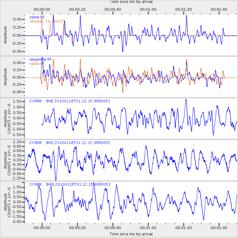
Signal To Noise
| Channel | StoN | STA | LTA |
| CI:SMM: :BHZ:20100118T01:12:15.488005Z | 0.80821145 | 3.335885E-7 | 4.1274905E-7 |
| CI:SMM: :BHN:20100118T01:12:15.488005Z | 2.344477 | 1.0537132E-6 | 4.4944488E-7 |
| CI:SMM: :BHE:20100118T01:12:15.488005Z | 1.1259394 | 5.357321E-7 | 4.75809E-7 |
| Arrivals |
| Ps | |
| PpPs | |
| PsPs/PpSs | |


