You are here: Home > Network List > CI - Caltech Regional Seismic Network Stations List
> Station BBR Big Bear Solar Observatory > Earthquake Result Viewer
BBR Big Bear Solar Observatory - Earthquake Result Viewer
| Earthquake location: |
Tonga Islands Region |
| Earthquake latitude/longitude: |
-19.3/-172.1 |
| Earthquake time(UTC): |
2022/11/11 (315) 10:48:45 GMT |
| Earthquake Depth: |
25 km |
| Earthquake Magnitude: |
7.3 Mww |
| Earthquake Catalog/Contributor: |
NEIC PDE/us |
|
| Network: |
CI Caltech Regional Seismic Network |
| Station: |
BBR Big Bear Solar Observatory |
| Lat/Lon: |
34.26 N/116.92 W |
| Elevation: |
2069 m |
|
| Distance: |
74.8 deg |
| Az: |
44.797 deg |
| Baz: |
233.459 deg |
| Ray Param: |
0.052069664 |
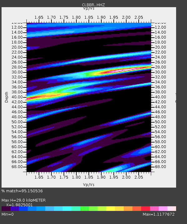
| Estimated Moho Depth: |
29.0 km |
| Estimated Crust Vp/Vs: |
1.98 |
| Assumed Crust Vp: |
6.276 km/s |
| Estimated Crust Vs: |
3.166 km/s |
| Estimated Crust Poisson's Ratio: |
0.33 |
|
| Radial Match: |
95.150536 % |
| Radial Bump: |
400 |
| Transverse Match: |
87.969986 % |
| Transverse Bump: |
400 |
| SOD ConfigId: |
29756493 |
| Insert Time: |
2022-11-25 11:03:37.236 +0000 |
| GWidth: |
2.5 |
| Max Bumps: |
400 |
| Tol: |
0.001 |
|

Signal To Noise
| Channel | StoN | STA | LTA |
| CI:BBR: :HHZ:20221111T10:59:51.888011Z | 18.647345 | 6.32627E-6 | 3.392585E-7 |
| CI:BBR: :HHN:20221111T10:59:51.888011Z | 2.5112906 | 9.751309E-7 | 3.8829873E-7 |
| CI:BBR: :HHE:20221111T10:59:51.888011Z | 4.6413755 | 1.8785233E-6 | 4.047342E-7 |
| Arrivals |
| Ps | 4.7 SECOND |
| PpPs | 13 SECOND |
| PsPs/PpSs | 18 SECOND |


