You are here: Home > Network List > CI - Caltech Regional Seismic Network Stations List
> Station MUR Murrieta > Earthquake Result Viewer
MUR Murrieta - Earthquake Result Viewer

| Earthquake location: |
Tonga Islands Region |
| Earthquake latitude/longitude: |
-19.3/-172.1 |
| Earthquake time(UTC): |
2022/11/11 (315) 10:48:45 GMT |
| Earthquake Depth: |
25 km |
| Earthquake Magnitude: |
7.3 Mww |
| Earthquake Catalog/Contributor: |
NEIC PDE/us |
|
| Network: |
CI Caltech Regional Seismic Network |
| Station: |
MUR Murrieta |
| Lat/Lon: |
33.60 N/117.20 W |
| Elevation: |
562 m |
|
| Distance: |
74.2 deg |
| Az: |
45.207 deg |
| Baz: |
233.415 deg |
| Ray Param: |
0.052467473 |
| Estimated Moho Depth: |
67.5 km |
| Estimated Crust Vp/Vs: |
1.70 |
| Assumed Crust Vp: |
6.264 km/s |
| Estimated Crust Vs: |
3.69 km/s |
| Estimated Crust Poisson's Ratio: |
0.23 |
|
| Radial Match: |
98.34379 % |
| Radial Bump: |
255 |
| Transverse Match: |
93.009735 % |
| Transverse Bump: |
384 |
| SOD ConfigId: |
29756493 |
| Insert Time: |
2022-11-25 11:04:39.592 +0000 |
| GWidth: |
2.5 |
| Max Bumps: |
400 |
| Tol: |
0.001 |
|
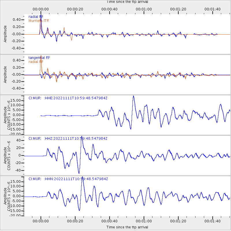
Signal To Noise
| Channel | StoN | STA | LTA |
| CI:MUR: :HHZ:20221111T10:59:48.547984Z | 24.324041 | 7.620585E-6 | 3.1329438E-7 |
| CI:MUR: :HHN:20221111T10:59:48.547984Z | 20.25023 | 1.8928931E-6 | 9.3475144E-8 |
| CI:MUR: :HHE:20221111T10:59:48.547984Z | 13.377843 | 2.351615E-6 | 1.7578431E-7 |
| Arrivals |
| Ps | 7.8 SECOND |
| PpPs | 28 SECOND |
| PsPs/PpSs | 36 SECOND |


