You are here: Home > Network List > CI - Caltech Regional Seismic Network Stations List
> Station VTV Victorville, California, USA > Earthquake Result Viewer
VTV Victorville, California, USA - Earthquake Result Viewer
| Earthquake location: |
Tonga Islands Region |
| Earthquake latitude/longitude: |
-19.3/-172.1 |
| Earthquake time(UTC): |
2022/11/11 (315) 10:48:45 GMT |
| Earthquake Depth: |
25 km |
| Earthquake Magnitude: |
7.3 Mww |
| Earthquake Catalog/Contributor: |
NEIC PDE/us |
|
| Network: |
CI Caltech Regional Seismic Network |
| Station: |
VTV Victorville, California, USA |
| Lat/Lon: |
34.56 N/117.33 W |
| Elevation: |
812 m |
|
| Distance: |
74.7 deg |
| Az: |
44.341 deg |
| Baz: |
233.108 deg |
| Ray Param: |
0.052134704 |
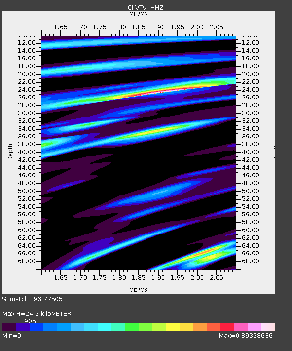
| Estimated Moho Depth: |
24.5 km |
| Estimated Crust Vp/Vs: |
1.90 |
| Assumed Crust Vp: |
6.276 km/s |
| Estimated Crust Vs: |
3.294 km/s |
| Estimated Crust Poisson's Ratio: |
0.31 |
|
| Radial Match: |
96.77505 % |
| Radial Bump: |
372 |
| Transverse Match: |
90.08269 % |
| Transverse Bump: |
400 |
| SOD ConfigId: |
29756493 |
| Insert Time: |
2022-11-25 11:05:41.176 +0000 |
| GWidth: |
2.5 |
| Max Bumps: |
400 |
| Tol: |
0.001 |
|

Signal To Noise
| Channel | StoN | STA | LTA |
| CI:VTV: :HHZ:20221111T10:59:51.347972Z | 23.45892 | 6.7630795E-6 | 2.882946E-7 |
| CI:VTV: :HHN:20221111T10:59:51.347972Z | 5.388239 | 1.2586137E-6 | 2.3358535E-7 |
| CI:VTV: :HHE:20221111T10:59:51.347972Z | 8.18736 | 2.186145E-6 | 2.6701466E-7 |
| Arrivals |
| Ps | 3.6 SECOND |
| PpPs | 11 SECOND |
| PsPs/PpSs | 15 SECOND |


