You are here: Home > Network List > CN - Canadian National Seismograph Network Stations List
> Station GDR Gold River, BC, CA > Earthquake Result Viewer
GDR Gold River, BC, CA - Earthquake Result Viewer
| Earthquake location: |
Tonga Islands Region |
| Earthquake latitude/longitude: |
-19.3/-172.1 |
| Earthquake time(UTC): |
2022/11/11 (315) 10:48:45 GMT |
| Earthquake Depth: |
25 km |
| Earthquake Magnitude: |
7.3 Mww |
| Earthquake Catalog/Contributor: |
NEIC PDE/us |
|
| Network: |
CN Canadian National Seismograph Network |
| Station: |
GDR Gold River, BC, CA |
| Lat/Lon: |
49.78 N/126.06 W |
| Elevation: |
123 m |
|
| Distance: |
79.9 deg |
| Az: |
28.29 deg |
| Baz: |
223.665 deg |
| Ray Param: |
0.048590332 |
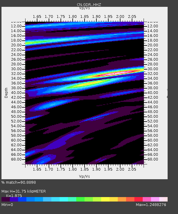
| Estimated Moho Depth: |
31.75 km |
| Estimated Crust Vp/Vs: |
1.98 |
| Assumed Crust Vp: |
6.24 km/s |
| Estimated Crust Vs: |
3.159 km/s |
| Estimated Crust Poisson's Ratio: |
0.33 |
|
| Radial Match: |
90.8898 % |
| Radial Bump: |
400 |
| Transverse Match: |
74.733955 % |
| Transverse Bump: |
400 |
| SOD ConfigId: |
29756493 |
| Insert Time: |
2022-11-25 11:06:29.931 +0000 |
| GWidth: |
2.5 |
| Max Bumps: |
400 |
| Tol: |
0.001 |
|

Signal To Noise
| Channel | StoN | STA | LTA |
| CN:GDR: :HHZ:20221111T11:00:20.659983Z | 6.493284 | 5.717729E-6 | 8.8056044E-7 |
| CN:GDR: :HHN:20221111T11:00:20.659983Z | 2.4455743 | 1.8818839E-6 | 7.695059E-7 |
| CN:GDR: :HHE:20221111T11:00:20.659983Z | 2.047265 | 1.922364E-6 | 9.389913E-7 |
| Arrivals |
| Ps | 5.1 SECOND |
| PpPs | 15 SECOND |
| PsPs/PpSs | 20 SECOND |


