You are here: Home > Network List > CN - Canadian National Seismograph Network Stations List
> Station PABB Port Alberni, BC, CA > Earthquake Result Viewer
PABB Port Alberni, BC, CA - Earthquake Result Viewer
| Earthquake location: |
Tonga Islands Region |
| Earthquake latitude/longitude: |
-19.3/-172.1 |
| Earthquake time(UTC): |
2022/11/11 (315) 10:48:45 GMT |
| Earthquake Depth: |
25 km |
| Earthquake Magnitude: |
7.3 Mww |
| Earthquake Catalog/Contributor: |
NEIC PDE/us |
|
| Network: |
CN Canadian National Seismograph Network |
| Station: |
PABB Port Alberni, BC, CA |
| Lat/Lon: |
49.22 N/124.81 W |
| Elevation: |
3.0 m |
|
| Distance: |
80.1 deg |
| Az: |
29.278 deg |
| Baz: |
224.78 deg |
| Ray Param: |
0.048478562 |
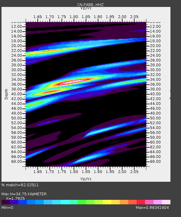
| Estimated Moho Depth: |
34.75 km |
| Estimated Crust Vp/Vs: |
1.79 |
| Assumed Crust Vp: |
6.391 km/s |
| Estimated Crust Vs: |
3.565 km/s |
| Estimated Crust Poisson's Ratio: |
0.27 |
|
| Radial Match: |
92.02511 % |
| Radial Bump: |
400 |
| Transverse Match: |
80.07284 % |
| Transverse Bump: |
400 |
| SOD ConfigId: |
29756493 |
| Insert Time: |
2022-11-25 11:07:01.311 +0000 |
| GWidth: |
2.5 |
| Max Bumps: |
400 |
| Tol: |
0.001 |
|

Signal To Noise
| Channel | StoN | STA | LTA |
| CN:PABB: :HHZ:20221111T11:00:21.539988Z | 6.756627 | 6.317758E-6 | 9.350461E-7 |
| CN:PABB: :HHN:20221111T11:00:21.539988Z | 3.4592912 | 1.7460636E-6 | 5.047461E-7 |
| CN:PABB: :HHE:20221111T11:00:21.539988Z | 1.9282119 | 2.0868067E-6 | 1.0822497E-6 |
| Arrivals |
| Ps | 4.4 SECOND |
| PpPs | 15 SECOND |
| PsPs/PpSs | 19 SECOND |


