You are here: Home > Network List > G - GEOSCOPE Stations List
> Station IVI Ivittuut, Greenland > Earthquake Result Viewer
IVI Ivittuut, Greenland - Earthquake Result Viewer
| Earthquake location: |
Dodecanese Islands, Greece |
| Earthquake latitude/longitude: |
36.9/27.5 |
| Earthquake time(UTC): |
2017/07/20 (201) 22:31:12 GMT |
| Earthquake Depth: |
10 km |
| Earthquake Magnitude: |
6.7 Mww |
| Earthquake Catalog/Contributor: |
NEIC PDE/us |
|
| Network: |
G GEOSCOPE |
| Station: |
IVI Ivittuut, Greenland |
| Lat/Lon: |
61.21 N/48.17 W |
| Elevation: |
15 m |
|
| Distance: |
51.7 deg |
| Az: |
323.292 deg |
| Baz: |
81.513 deg |
| Ray Param: |
0.06725119 |
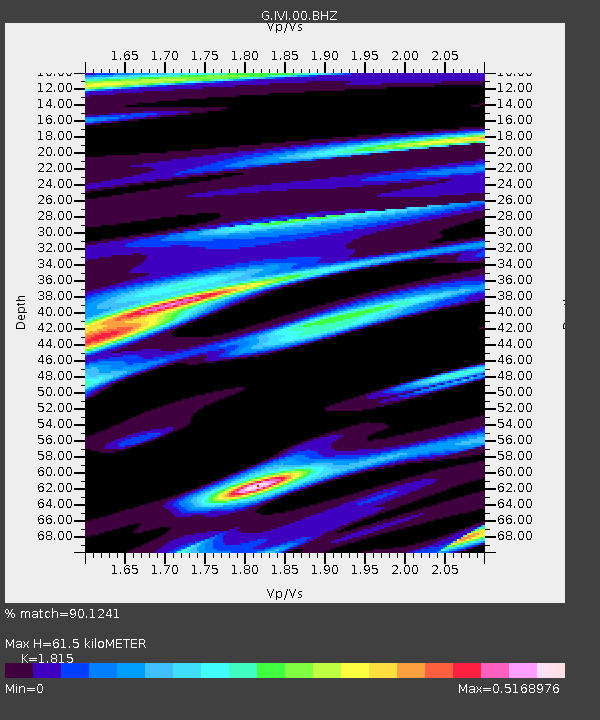
| Estimated Moho Depth: |
61.5 km |
| Estimated Crust Vp/Vs: |
1.82 |
| Assumed Crust Vp: |
6.472 km/s |
| Estimated Crust Vs: |
3.566 km/s |
| Estimated Crust Poisson's Ratio: |
0.28 |
|
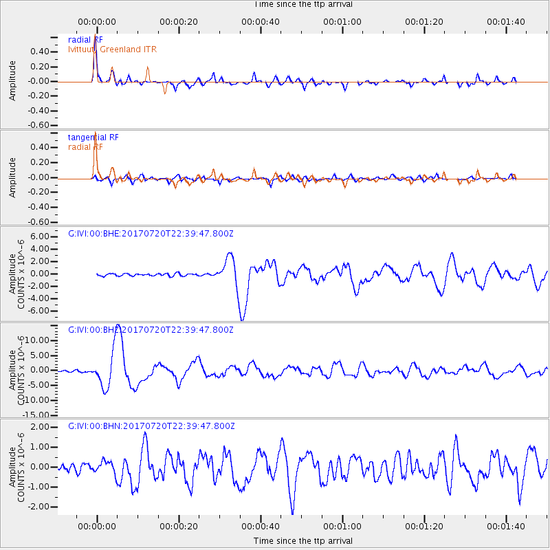
| Radial Match: |
90.1241 % |
| Radial Bump: |
388 |
| Transverse Match: |
75.25585 % |
| Transverse Bump: |
400 |
| SOD ConfigId: |
2973751 |
| Insert Time: |
2018-10-08 19:55:52.247 +0000 |
| GWidth: |
2.5 |
| Max Bumps: |
400 |
| Tol: |
0.001 |
|
Signal To Noise
| Channel | StoN | STA | LTA |
| G:IVI:00:BHZ:20170720T22:39:47.800Z | 23.518282 | 6.5873837E-6 | 2.800963E-7 |
| G:IVI:00:BHN:20170720T22:39:47.800Z | 1.3620268 | 3.1572304E-7 | 2.3180384E-7 |
| G:IVI:00:BHE:20170720T22:39:47.800Z | 15.5362 | 2.8270174E-6 | 1.8196326E-7 |
| Arrivals |
| Ps | 8.2 SECOND |
| PpPs | 25 SECOND |
| PsPs/PpSs | 33 SECOND |


