You are here: Home > Network List > GM - US Geological Survey Networks Stations List
> Station NMP25 New Mexico Permian - Site# W2S5 > Earthquake Result Viewer
NMP25 New Mexico Permian - Site# W2S5 - Earthquake Result Viewer
| Earthquake location: |
Tonga Islands Region |
| Earthquake latitude/longitude: |
-19.3/-172.1 |
| Earthquake time(UTC): |
2022/11/11 (315) 10:48:45 GMT |
| Earthquake Depth: |
25 km |
| Earthquake Magnitude: |
7.3 Mww |
| Earthquake Catalog/Contributor: |
NEIC PDE/us |
|
| Network: |
GM US Geological Survey Networks |
| Station: |
NMP25 New Mexico Permian - Site# W2S5 |
| Lat/Lon: |
32.34 N/103.86 W |
| Elevation: |
983 m |
|
| Distance: |
83.0 deg |
| Az: |
52.378 deg |
| Baz: |
242.082 deg |
| Ray Param: |
0.046450045 |
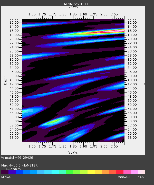
| Estimated Moho Depth: |
15.5 km |
| Estimated Crust Vp/Vs: |
2.10 |
| Assumed Crust Vp: |
6.129 km/s |
| Estimated Crust Vs: |
2.922 km/s |
| Estimated Crust Poisson's Ratio: |
0.35 |
|
| Radial Match: |
91.29429 % |
| Radial Bump: |
382 |
| Transverse Match: |
87.86488 % |
| Transverse Bump: |
400 |
| SOD ConfigId: |
29756493 |
| Insert Time: |
2022-11-25 11:09:05.235 +0000 |
| GWidth: |
2.5 |
| Max Bumps: |
400 |
| Tol: |
0.001 |
|

Signal To Noise
| Channel | StoN | STA | LTA |
| GM:NMP25:01:HHZ:20221111T11:00:36.909983Z | 25.14669 | 8.767984E-6 | 3.4867344E-7 |
| GM:NMP25:01:HHN:20221111T11:00:36.909983Z | 6.788911 | 1.0364133E-6 | 1.5266268E-7 |
| GM:NMP25:01:HHE:20221111T11:00:36.909983Z | 7.3202496 | 1.7322737E-6 | 2.3664136E-7 |
| Arrivals |
| Ps | 2.8 SECOND |
| PpPs | 7.7 SECOND |
| PsPs/PpSs | 11 SECOND |


