You are here: Home > Network List > GM - US Geological Survey Networks Stations List
> Station NMP45 New Mexico Permian - Site# W4S5 > Earthquake Result Viewer
NMP45 New Mexico Permian - Site# W4S5 - Earthquake Result Viewer
| Earthquake location: |
Tonga Islands Region |
| Earthquake latitude/longitude: |
-19.3/-172.1 |
| Earthquake time(UTC): |
2022/11/11 (315) 10:48:45 GMT |
| Earthquake Depth: |
25 km |
| Earthquake Magnitude: |
7.3 Mww |
| Earthquake Catalog/Contributor: |
NEIC PDE/us |
|
| Network: |
GM US Geological Survey Networks |
| Station: |
NMP45 New Mexico Permian - Site# W4S5 |
| Lat/Lon: |
32.33 N/103.58 W |
| Elevation: |
1127 m |
|
| Distance: |
83.2 deg |
| Az: |
52.495 deg |
| Baz: |
242.244 deg |
| Ray Param: |
0.046306133 |
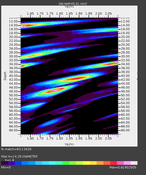
| Estimated Moho Depth: |
14.25 km |
| Estimated Crust Vp/Vs: |
1.60 |
| Assumed Crust Vp: |
6.129 km/s |
| Estimated Crust Vs: |
3.831 km/s |
| Estimated Crust Poisson's Ratio: |
0.18 |
|
| Radial Match: |
93.13428 % |
| Radial Bump: |
362 |
| Transverse Match: |
83.21273 % |
| Transverse Bump: |
400 |
| SOD ConfigId: |
29756493 |
| Insert Time: |
2022-11-25 11:09:15.273 +0000 |
| GWidth: |
2.5 |
| Max Bumps: |
400 |
| Tol: |
0.001 |
|

Signal To Noise
| Channel | StoN | STA | LTA |
| GM:NMP45:01:HHZ:20221111T11:00:37.964976Z | 32.534405 | 8.581133E-6 | 2.6375568E-7 |
| GM:NMP45:01:HHN:20221111T11:00:37.964976Z | 2.3121815 | 1.4356242E-6 | 6.20896E-7 |
| GM:NMP45:01:HHE:20221111T11:00:37.964976Z | 5.139373 | 1.8465216E-6 | 3.592893E-7 |
| Arrivals |
| Ps | 1.4 SECOND |
| PpPs | 5.9 SECOND |
| PsPs/PpSs | 7.3 SECOND |


