You are here: Home > Network List > GS - US Geological Survey Networks Stations List
> Station ASA4 ASA4 > Earthquake Result Viewer
ASA4 ASA4 - Earthquake Result Viewer
| Earthquake location: |
Tonga Islands Region |
| Earthquake latitude/longitude: |
-19.3/-172.1 |
| Earthquake time(UTC): |
2022/11/11 (315) 10:48:45 GMT |
| Earthquake Depth: |
25 km |
| Earthquake Magnitude: |
7.3 Mww |
| Earthquake Catalog/Contributor: |
NEIC PDE/us |
|
| Network: |
GS US Geological Survey Networks |
| Station: |
ASA4 ASA4 |
| Lat/Lon: |
34.94 N/106.46 W |
| Elevation: |
1820 m |
|
| Distance: |
82.4 deg |
| Az: |
49.029 deg |
| Baz: |
240.221 deg |
| Ray Param: |
0.046899956 |
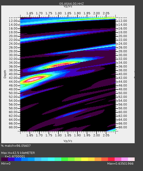
| Estimated Moho Depth: |
42.5 km |
| Estimated Crust Vp/Vs: |
1.67 |
| Assumed Crust Vp: |
6.502 km/s |
| Estimated Crust Vs: |
3.893 km/s |
| Estimated Crust Poisson's Ratio: |
0.22 |
|
| Radial Match: |
96.05607 % |
| Radial Bump: |
207 |
| Transverse Match: |
94.67059 % |
| Transverse Bump: |
352 |
| SOD ConfigId: |
29756493 |
| Insert Time: |
2022-11-25 11:09:28.436 +0000 |
| GWidth: |
2.5 |
| Max Bumps: |
400 |
| Tol: |
0.001 |
|

Signal To Noise
| Channel | StoN | STA | LTA |
| GS:ASA4:00:HHZ:20221111T11:00:33.549998Z | 16.418026 | 4.210239E-6 | 2.5644E-7 |
| GS:ASA4:00:HH1:20221111T11:00:33.549998Z | 7.873604 | 9.137571E-7 | 1.1605322E-7 |
| GS:ASA4:00:HH2:20221111T11:00:33.549998Z | 11.2042885 | 1.0694746E-6 | 9.545226E-8 |
| Arrivals |
| Ps | 4.5 SECOND |
| PpPs | 17 SECOND |
| PsPs/PpSs | 21 SECOND |


