You are here: Home > Network List > IU - Global Seismograph Network (GSN - IRIS/USGS) Stations List
> Station CTAO Charters Towers, Australia > Earthquake Result Viewer
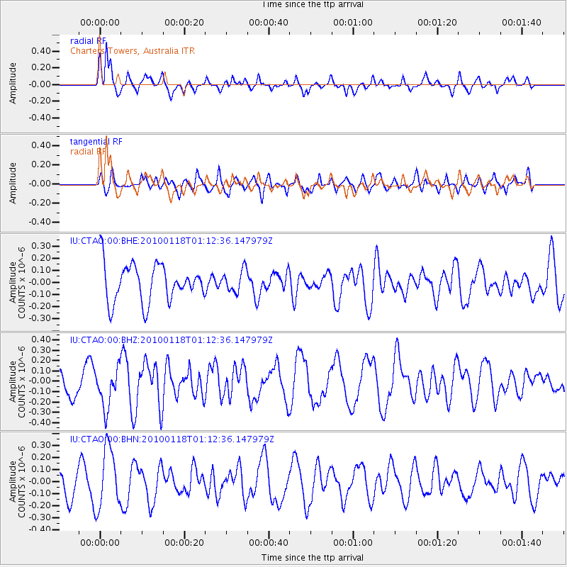
CTAO Charters Towers, Australia - Earthquake Result Viewer
*The percent match for this event was below the threshold and hence no stack was calculated.
| Earthquake location: |
Kuril Islands |
| Earthquake latitude/longitude: |
46.5/153.3 |
| Earthquake time(UTC): |
2010/01/18 (018) 01:02:16 GMT |
| Earthquake Depth: |
7.0 km |
| Earthquake Magnitude: |
5.6 MB, 5.3 MS, 5.6 MW, 5.6 MW |
| Earthquake Catalog/Contributor: |
WHDF/NEIC |
|
| Network: |
IU Global Seismograph Network (GSN - IRIS/USGS) |
| Station: |
CTAO Charters Towers, Australia |
| Lat/Lon: |
20.09 S/146.25 E |
| Elevation: |
357 m |
|
| Distance: |
66.6 deg |
| Az: |
187.18 deg |
| Baz: |
5.272 deg |
| Ray Param: |
$rayparam |
*The percent match for this event was below the threshold and hence was not used in the summary stack. |
|
| Radial Match: |
70.909805 % |
| Radial Bump: |
400 |
| Transverse Match: |
46.845127 % |
| Transverse Bump: |
400 |
| SOD ConfigId: |
296938 |
| Insert Time: |
2010-04-06 21:08:58.840 +0000 |
| GWidth: |
2.5 |
| Max Bumps: |
400 |
| Tol: |
0.001 |
|
Signal To Noise
| Channel | StoN | STA | LTA |
| IU:CTAO:00:BHZ:20100118T01:12:36.147979Z | 2.2553334 | 1.9479539E-7 | 8.6370996E-8 |
| IU:CTAO:00:BHN:20100118T01:12:36.147979Z | 2.544321 | 2.4919703E-7 | 9.7942454E-8 |
| IU:CTAO:00:BHE:20100118T01:12:36.147979Z | 0.60434234 | 9.279722E-8 | 1.5355074E-7 |
| Arrivals |
| Ps | |
| PpPs | |
| PsPs/PpSs | |


