You are here: Home > Network List > IM - International Miscellaneous Stations Stations List
> Station PD31 PDAR Array, Pinedale, WY, USA > Earthquake Result Viewer
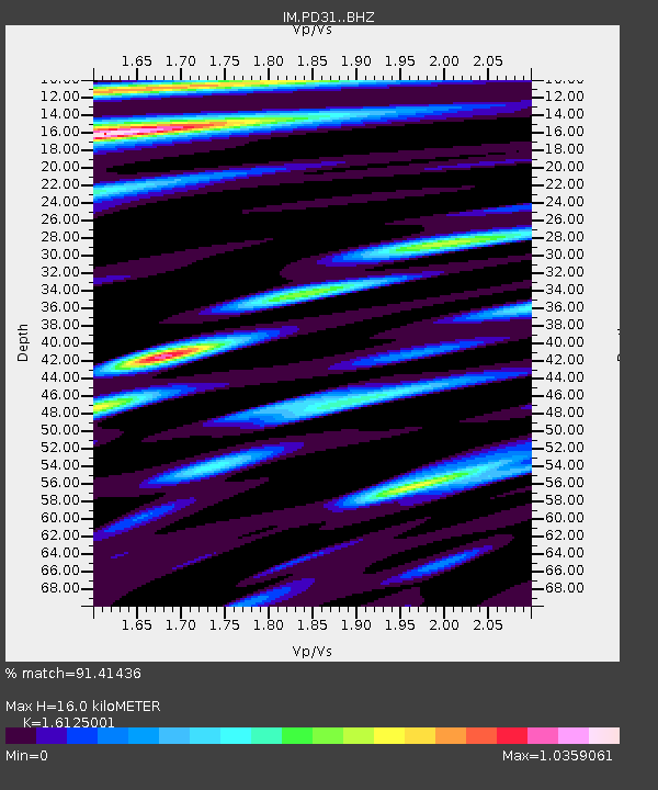
PD31 PDAR Array, Pinedale, WY, USA - Earthquake Result Viewer
| Earthquake location: |
Tonga Islands Region |
| Earthquake latitude/longitude: |
-19.3/-172.1 |
| Earthquake time(UTC): |
2022/11/11 (315) 10:48:45 GMT |
| Earthquake Depth: |
25 km |
| Earthquake Magnitude: |
7.3 Mww |
| Earthquake Catalog/Contributor: |
NEIC PDE/us |
|
| Network: |
IM International Miscellaneous Stations |
| Station: |
PD31 PDAR Array, Pinedale, WY, USA |
| Lat/Lon: |
42.77 N/109.56 W |
| Elevation: |
2219 m |
|
| Distance: |
84.4 deg |
| Az: |
41.041 deg |
| Baz: |
237.359 deg |
| Ray Param: |
0.04551064 |
| Estimated Moho Depth: |
16.0 km |
| Estimated Crust Vp/Vs: |
1.61 |
| Assumed Crust Vp: |
6.161 km/s |
| Estimated Crust Vs: |
3.821 km/s |
| Estimated Crust Poisson's Ratio: |
0.19 |
|
| Radial Match: |
91.41436 % |
| Radial Bump: |
400 |
| Transverse Match: |
92.631905 % |
| Transverse Bump: |
400 |
| SOD ConfigId: |
29756493 |
| Insert Time: |
2022-11-25 11:11:05.439 +0000 |
| GWidth: |
2.5 |
| Max Bumps: |
400 |
| Tol: |
0.001 |
|

Signal To Noise
| Channel | StoN | STA | LTA |
| IM:PD31: :BHZ:20221111T11:00:43.724009Z | 61.219585 | 8.525191E-6 | 1.3925595E-7 |
| IM:PD31: :BHN:20221111T11:00:43.724009Z | 7.4148784 | 9.633671E-7 | 1.2992354E-7 |
| IM:PD31: :BHE:20221111T11:00:43.724009Z | 5.5033116 | 9.803143E-7 | 1.7813171E-7 |
| Arrivals |
| Ps | 1.6 SECOND |
| PpPs | 6.6 SECOND |
| PsPs/PpSs | 8.2 SECOND |


