You are here: Home > Network List > IM - International Miscellaneous Stations Stations List
> Station SHEM Shemya Island, Alaska, USA > Earthquake Result Viewer
SHEM Shemya Island, Alaska, USA - Earthquake Result Viewer
| Earthquake location: |
Tonga Islands Region |
| Earthquake latitude/longitude: |
-19.3/-172.1 |
| Earthquake time(UTC): |
2022/11/11 (315) 10:48:45 GMT |
| Earthquake Depth: |
25 km |
| Earthquake Magnitude: |
7.3 Mww |
| Earthquake Catalog/Contributor: |
NEIC PDE/us |
|
| Network: |
IM International Miscellaneous Stations |
| Station: |
SHEM Shemya Island, Alaska, USA |
| Lat/Lon: |
52.73 N/174.10 E |
| Elevation: |
580 m |
|
| Distance: |
72.7 deg |
| Az: |
351.262 deg |
| Baz: |
166.355 deg |
| Ray Param: |
0.053444624 |
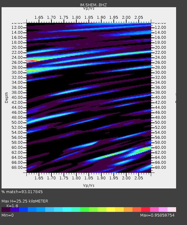
| Estimated Moho Depth: |
25.25 km |
| Estimated Crust Vp/Vs: |
1.60 |
| Assumed Crust Vp: |
3.999 km/s |
| Estimated Crust Vs: |
2.499 km/s |
| Estimated Crust Poisson's Ratio: |
0.18 |
|
| Radial Match: |
93.017845 % |
| Radial Bump: |
369 |
| Transverse Match: |
90.21084 % |
| Transverse Bump: |
400 |
| SOD ConfigId: |
29756493 |
| Insert Time: |
2022-11-25 11:11:06.693 +0000 |
| GWidth: |
2.5 |
| Max Bumps: |
400 |
| Tol: |
0.001 |
|

Signal To Noise
| Channel | StoN | STA | LTA |
| IM:SHEM: :BHZ:20221111T10:59:39.899974Z | 8.787689 | 1.1250283E-5 | 1.2802323E-6 |
| IM:SHEM: :BHN:20221111T10:59:39.899974Z | 2.0723262 | 4.6974487E-6 | 2.2667516E-6 |
| IM:SHEM: :BHE:20221111T10:59:39.899974Z | 1.244918 | 3.0157935E-6 | 2.4224837E-6 |
| Arrivals |
| Ps | 3.8 SECOND |
| PpPs | 16 SECOND |
| PsPs/PpSs | 20 SECOND |


