You are here: Home > Network List > IU - Global Seismograph Network (GSN - IRIS/USGS) Stations List
> Station COR Corvallis, Oregon, USA > Earthquake Result Viewer
COR Corvallis, Oregon, USA - Earthquake Result Viewer
| Earthquake location: |
Tonga Islands Region |
| Earthquake latitude/longitude: |
-19.3/-172.1 |
| Earthquake time(UTC): |
2022/11/11 (315) 10:48:45 GMT |
| Earthquake Depth: |
25 km |
| Earthquake Magnitude: |
7.3 Mww |
| Earthquake Catalog/Contributor: |
NEIC PDE/us |
|
| Network: |
IU Global Seismograph Network (GSN - IRIS/USGS) |
| Station: |
COR Corvallis, Oregon, USA |
| Lat/Lon: |
44.59 N/123.30 W |
| Elevation: |
121 m |
|
| Distance: |
77.6 deg |
| Az: |
33.396 deg |
| Baz: |
226.674 deg |
| Ray Param: |
0.05018368 |
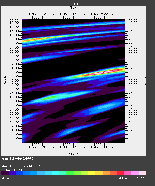
| Estimated Moho Depth: |
35.75 km |
| Estimated Crust Vp/Vs: |
1.99 |
| Assumed Crust Vp: |
6.566 km/s |
| Estimated Crust Vs: |
3.295 km/s |
| Estimated Crust Poisson's Ratio: |
0.33 |
|
| Radial Match: |
96.16995 % |
| Radial Bump: |
397 |
| Transverse Match: |
92.53414 % |
| Transverse Bump: |
354 |
| SOD ConfigId: |
29756493 |
| Insert Time: |
2022-11-25 11:11:17.181 +0000 |
| GWidth: |
2.5 |
| Max Bumps: |
400 |
| Tol: |
0.001 |
|
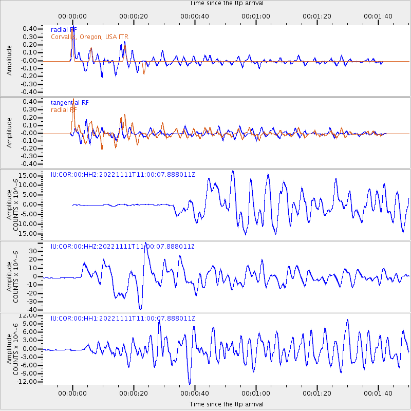
Signal To Noise
| Channel | StoN | STA | LTA |
| IU:COR:00:HHZ:20221111T11:00:07.888011Z | 23.263405 | 7.574208E-6 | 3.2558467E-7 |
| IU:COR:00:HH1:20221111T11:00:07.888011Z | 3.0872402 | 4.723539E-7 | 1.5300199E-7 |
| IU:COR:00:HH2:20221111T11:00:07.888011Z | 9.607297 | 2.4801477E-6 | 2.581525E-7 |
| Arrivals |
| Ps | 5.6 SECOND |
| PpPs | 16 SECOND |
| PsPs/PpSs | 21 SECOND |


