You are here: Home > Network List > IW - Intermountain West Stations List
> Station PLID Pearl Lake, Idaho, USA > Earthquake Result Viewer
PLID Pearl Lake, Idaho, USA - Earthquake Result Viewer
| Earthquake location: |
Tonga Islands Region |
| Earthquake latitude/longitude: |
-19.3/-172.1 |
| Earthquake time(UTC): |
2022/11/11 (315) 10:48:45 GMT |
| Earthquake Depth: |
25 km |
| Earthquake Magnitude: |
7.3 Mww |
| Earthquake Catalog/Contributor: |
NEIC PDE/us |
|
| Network: |
IW Intermountain West |
| Station: |
PLID Pearl Lake, Idaho, USA |
| Lat/Lon: |
45.09 N/116.00 W |
| Elevation: |
2164 m |
|
| Distance: |
81.9 deg |
| Az: |
36.435 deg |
| Baz: |
232.351 deg |
| Ray Param: |
0.047242112 |
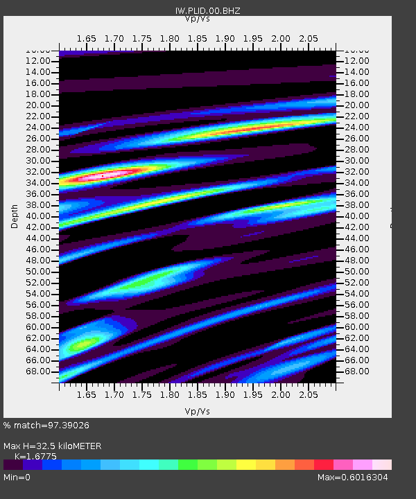
| Estimated Moho Depth: |
32.5 km |
| Estimated Crust Vp/Vs: |
1.68 |
| Assumed Crust Vp: |
6.571 km/s |
| Estimated Crust Vs: |
3.917 km/s |
| Estimated Crust Poisson's Ratio: |
0.22 |
|
| Radial Match: |
97.39026 % |
| Radial Bump: |
400 |
| Transverse Match: |
93.886955 % |
| Transverse Bump: |
400 |
| SOD ConfigId: |
29756493 |
| Insert Time: |
2022-11-25 11:11:58.707 +0000 |
| GWidth: |
2.5 |
| Max Bumps: |
400 |
| Tol: |
0.001 |
|

Signal To Noise
| Channel | StoN | STA | LTA |
| IW:PLID:00:BHZ:20221111T11:00:31.00001Z | 38.747017 | 7.4851328E-6 | 1.9317959E-7 |
| IW:PLID:00:BH1:20221111T11:00:31.00001Z | 14.54666 | 1.635562E-6 | 1.12435565E-7 |
| IW:PLID:00:BH2:20221111T11:00:31.00001Z | 12.197899 | 2.141721E-6 | 1.7558115E-7 |
| Arrivals |
| Ps | 3.5 SECOND |
| PpPs | 13 SECOND |
| PsPs/PpSs | 16 SECOND |


