You are here: Home > Network List > JP - Japan Meteorological Agency Seismic Network Stations List
> Station JMN Kochi Monobe > Earthquake Result Viewer
JMN Kochi Monobe - Earthquake Result Viewer
| Earthquake location: |
Tonga Islands Region |
| Earthquake latitude/longitude: |
-19.3/-172.1 |
| Earthquake time(UTC): |
2022/11/11 (315) 10:48:45 GMT |
| Earthquake Depth: |
25 km |
| Earthquake Magnitude: |
7.3 Mww |
| Earthquake Catalog/Contributor: |
NEIC PDE/us |
|
| Network: |
JP Japan Meteorological Agency Seismic Network |
| Station: |
JMN Kochi Monobe |
| Lat/Lon: |
33.73 N/133.88 E |
| Elevation: |
550 m |
|
| Distance: |
73.7 deg |
| Az: |
315.361 deg |
| Baz: |
127.228 deg |
| Ray Param: |
0.052801546 |
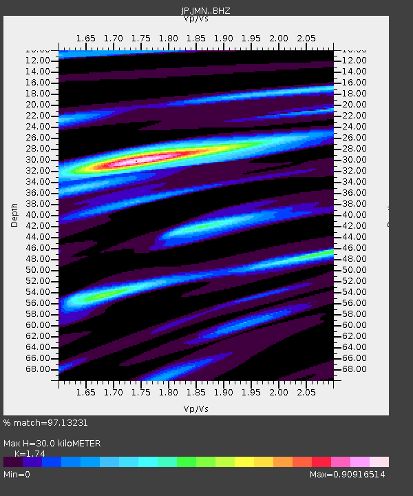
| Estimated Moho Depth: |
30.0 km |
| Estimated Crust Vp/Vs: |
1.74 |
| Assumed Crust Vp: |
6.468 km/s |
| Estimated Crust Vs: |
3.717 km/s |
| Estimated Crust Poisson's Ratio: |
0.25 |
|
| Radial Match: |
97.13231 % |
| Radial Bump: |
400 |
| Transverse Match: |
92.58232 % |
| Transverse Bump: |
400 |
| SOD ConfigId: |
29756493 |
| Insert Time: |
2022-11-25 11:12:12.543 +0000 |
| GWidth: |
2.5 |
| Max Bumps: |
400 |
| Tol: |
0.001 |
|

Signal To Noise
| Channel | StoN | STA | LTA |
| JP:JMN: :BHZ:20221111T10:59:45.599986Z | 55.22318 | 7.0495335E-6 | 1.2765534E-7 |
| JP:JMN: :BHN:20221111T10:59:45.599986Z | 22.092108 | 2.1580738E-6 | 9.768528E-8 |
| JP:JMN: :BHE:20221111T10:59:45.599986Z | 20.44139 | 1.9598967E-6 | 9.587884E-8 |
| Arrivals |
| Ps | 3.6 SECOND |
| PpPs | 12 SECOND |
| PsPs/PpSs | 16 SECOND |


