You are here: Home > Network List > N4 - Central and EAstern US Network Stations List
> Station I40B Norwalk, WI, USA > Earthquake Result Viewer
I40B Norwalk, WI, USA - Earthquake Result Viewer
| Earthquake location: |
Tonga Islands Region |
| Earthquake latitude/longitude: |
-19.3/-172.1 |
| Earthquake time(UTC): |
2022/11/11 (315) 10:48:45 GMT |
| Earthquake Depth: |
25 km |
| Earthquake Magnitude: |
7.3 Mww |
| Earthquake Catalog/Contributor: |
NEIC PDE/us |
|
| Network: |
N4 Central and EAstern US Network |
| Station: |
I40B Norwalk, WI, USA |
| Lat/Lon: |
43.89 N/90.62 W |
| Elevation: |
419 m |
|
| Distance: |
97.2 deg |
| Az: |
46.116 deg |
| Baz: |
250.302 deg |
| Ray Param: |
0.040267617 |
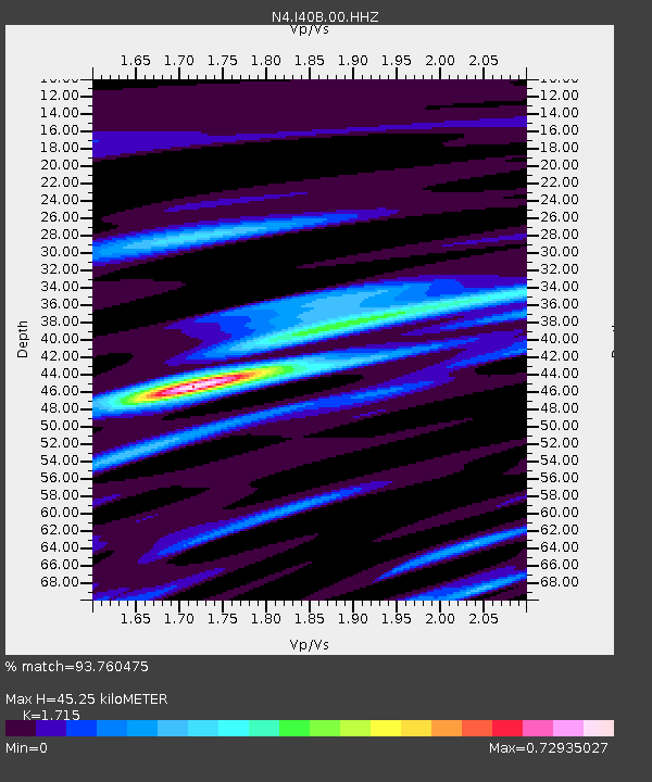
| Estimated Moho Depth: |
45.25 km |
| Estimated Crust Vp/Vs: |
1.72 |
| Assumed Crust Vp: |
6.53 km/s |
| Estimated Crust Vs: |
3.808 km/s |
| Estimated Crust Poisson's Ratio: |
0.24 |
|
| Radial Match: |
93.760475 % |
| Radial Bump: |
288 |
| Transverse Match: |
75.90441 % |
| Transverse Bump: |
400 |
| SOD ConfigId: |
29756493 |
| Insert Time: |
2022-11-25 11:13:27.302 +0000 |
| GWidth: |
2.5 |
| Max Bumps: |
400 |
| Tol: |
0.001 |
|

Signal To Noise
| Channel | StoN | STA | LTA |
| N4:I40B:00:HHZ:20221111T11:01:43.979991Z | 7.3611245 | 2.678339E-6 | 3.6384913E-7 |
| N4:I40B:00:HH1:20221111T11:01:43.979991Z | 1.2894284 | 5.4528465E-7 | 4.228887E-7 |
| N4:I40B:00:HH2:20221111T11:01:43.979991Z | 4.004205 | 8.4911625E-7 | 2.1205614E-7 |
| Arrivals |
| Ps | 5.1 SECOND |
| PpPs | 18 SECOND |
| PsPs/PpSs | 23 SECOND |


