You are here: Home > Network List > N4 - Central and EAstern US Network Stations List
> Station N35B Tabor, IA, USA > Earthquake Result Viewer
N35B Tabor, IA, USA - Earthquake Result Viewer
| Earthquake location: |
Tonga Islands Region |
| Earthquake latitude/longitude: |
-19.3/-172.1 |
| Earthquake time(UTC): |
2022/11/11 (315) 10:48:45 GMT |
| Earthquake Depth: |
25 km |
| Earthquake Magnitude: |
7.3 Mww |
| Earthquake Catalog/Contributor: |
NEIC PDE/us |
|
| Network: |
N4 Central and EAstern US Network |
| Station: |
N35B Tabor, IA, USA |
| Lat/Lon: |
40.86 N/95.64 W |
| Elevation: |
353 m |
|
| Distance: |
92.7 deg |
| Az: |
47.577 deg |
| Baz: |
246.799 deg |
| Ray Param: |
0.04141142 |
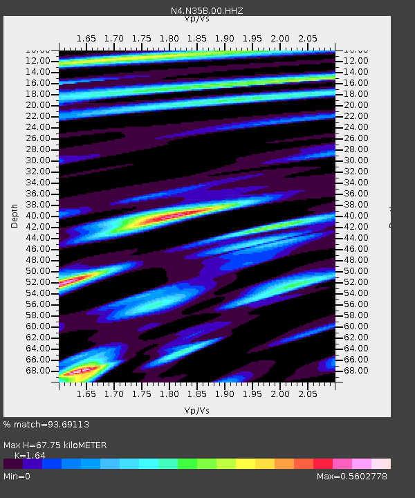
| Estimated Moho Depth: |
67.75 km |
| Estimated Crust Vp/Vs: |
1.64 |
| Assumed Crust Vp: |
6.498 km/s |
| Estimated Crust Vs: |
3.962 km/s |
| Estimated Crust Poisson's Ratio: |
0.20 |
|
| Radial Match: |
93.69113 % |
| Radial Bump: |
305 |
| Transverse Match: |
88.83552 % |
| Transverse Bump: |
400 |
| SOD ConfigId: |
29756493 |
| Insert Time: |
2022-11-25 11:13:41.017 +0000 |
| GWidth: |
2.5 |
| Max Bumps: |
400 |
| Tol: |
0.001 |
|

Signal To Noise
| Channel | StoN | STA | LTA |
| N4:N35B:00:HHZ:20221111T11:01:23.240Z | 16.28526 | 5.4944535E-6 | 3.3738814E-7 |
| N4:N35B:00:HH1:20221111T11:01:23.240Z | 3.1836174 | 1.1977232E-6 | 3.7621456E-7 |
| N4:N35B:00:HH2:20221111T11:01:23.240Z | 3.9325848 | 1.4619906E-6 | 3.7176326E-7 |
| Arrivals |
| Ps | 6.8 SECOND |
| PpPs | 27 SECOND |
| PsPs/PpSs | 34 SECOND |


