You are here: Home > Network List > NM - Cooperative New Madrid Seismic Network Stations List
> Station PEBM Pemiscot Bayou,MO > Earthquake Result Viewer
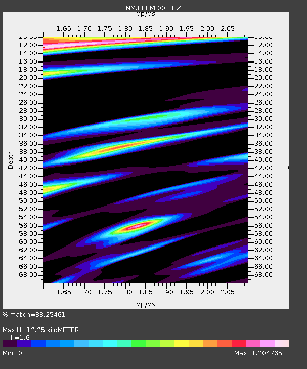
PEBM Pemiscot Bayou,MO - Earthquake Result Viewer
| Earthquake location: |
Tonga Islands Region |
| Earthquake latitude/longitude: |
-19.3/-172.1 |
| Earthquake time(UTC): |
2022/11/11 (315) 10:48:45 GMT |
| Earthquake Depth: |
25 km |
| Earthquake Magnitude: |
7.3 Mww |
| Earthquake Catalog/Contributor: |
NEIC PDE/us |
|
| Network: |
NM Cooperative New Madrid Seismic Network |
| Station: |
PEBM Pemiscot Bayou,MO |
| Lat/Lon: |
36.11 N/89.86 W |
| Elevation: |
76 m |
|
| Distance: |
95.1 deg |
| Az: |
53.665 deg |
| Baz: |
249.971 deg |
| Ray Param: |
0.040860794 |
| Estimated Moho Depth: |
12.25 km |
| Estimated Crust Vp/Vs: |
1.60 |
| Assumed Crust Vp: |
6.444 km/s |
| Estimated Crust Vs: |
4.027 km/s |
| Estimated Crust Poisson's Ratio: |
0.18 |
|
| Radial Match: |
88.25461 % |
| Radial Bump: |
276 |
| Transverse Match: |
78.809296 % |
| Transverse Bump: |
330 |
| SOD ConfigId: |
29756493 |
| Insert Time: |
2022-11-25 11:14:53.302 +0000 |
| GWidth: |
2.5 |
| Max Bumps: |
400 |
| Tol: |
0.001 |
|

Signal To Noise
| Channel | StoN | STA | LTA |
| NM:PEBM:00:HHZ:20221111T11:01:34.539988Z | 7.7878346 | 3.3275546E-6 | 4.2727595E-7 |
| NM:PEBM:00:HHN:20221111T11:01:34.539988Z | 0.4988555 | 5.287384E-7 | 1.0599028E-6 |
| NM:PEBM:00:HHE:20221111T11:01:34.539988Z | 0.7723401 | 1.1816268E-6 | 1.5299306E-6 |
| Arrivals |
| Ps | 1.2 SECOND |
| PpPs | 4.8 SECOND |
| PsPs/PpSs | 6.0 SECOND |


