You are here: Home > Network List > O2 - Oklahoma Consolidated Temporary Seismic Networks Stations List
> Station CHAN Chandler, Oklahoma, USA > Earthquake Result Viewer
CHAN Chandler, Oklahoma, USA - Earthquake Result Viewer
| Earthquake location: |
Tonga Islands Region |
| Earthquake latitude/longitude: |
-19.3/-172.1 |
| Earthquake time(UTC): |
2022/11/11 (315) 10:48:45 GMT |
| Earthquake Depth: |
25 km |
| Earthquake Magnitude: |
7.3 Mww |
| Earthquake Catalog/Contributor: |
NEIC PDE/us |
|
| Network: |
O2 Oklahoma Consolidated Temporary Seismic Networks |
| Station: |
CHAN Chandler, Oklahoma, USA |
| Lat/Lon: |
35.65 N/96.79 W |
| Elevation: |
266 m |
|
| Distance: |
89.8 deg |
| Az: |
51.982 deg |
| Baz: |
246.0 deg |
| Ray Param: |
0.041731432 |
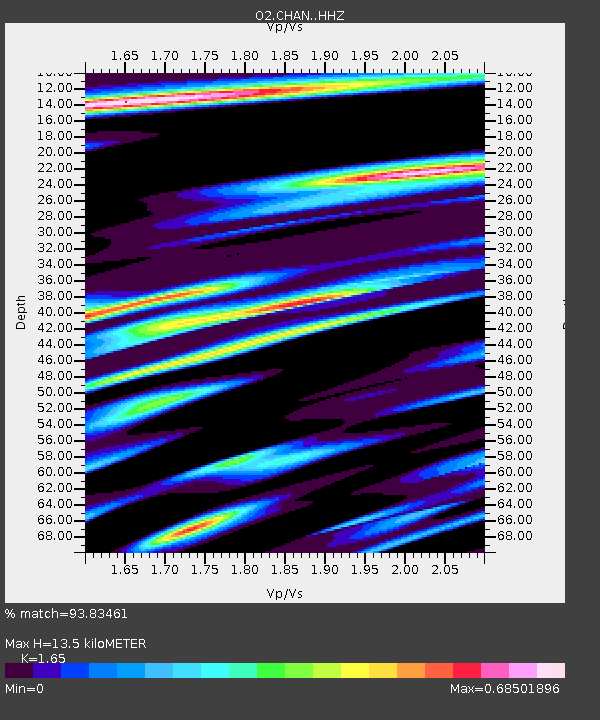
| Estimated Moho Depth: |
13.5 km |
| Estimated Crust Vp/Vs: |
1.65 |
| Assumed Crust Vp: |
6.426 km/s |
| Estimated Crust Vs: |
3.895 km/s |
| Estimated Crust Poisson's Ratio: |
0.21 |
|
| Radial Match: |
93.83461 % |
| Radial Bump: |
343 |
| Transverse Match: |
82.42914 % |
| Transverse Bump: |
400 |
| SOD ConfigId: |
29756493 |
| Insert Time: |
2022-11-25 11:16:59.051 +0000 |
| GWidth: |
2.5 |
| Max Bumps: |
400 |
| Tol: |
0.001 |
|

Signal To Noise
| Channel | StoN | STA | LTA |
| O2:CHAN: :HHZ:20221111T11:01:09.815013Z | 25.289145 | 6.7865008E-6 | 2.6835627E-7 |
| O2:CHAN: :HHN:20221111T11:01:09.815013Z | 2.932717 | 1.0659725E-6 | 3.6347606E-7 |
| O2:CHAN: :HHE:20221111T11:01:09.815013Z | 6.5613847 | 1.8585125E-6 | 2.8325005E-7 |
| Arrivals |
| Ps | 1.4 SECOND |
| PpPs | 5.4 SECOND |
| PsPs/PpSs | 6.8 SECOND |


