You are here: Home > Network List > O2 - Oklahoma Consolidated Temporary Seismic Networks Stations List
> Station DUST Dustin, Oklahoma, USA > Earthquake Result Viewer
DUST Dustin, Oklahoma, USA - Earthquake Result Viewer
| Earthquake location: |
Tonga Islands Region |
| Earthquake latitude/longitude: |
-19.3/-172.1 |
| Earthquake time(UTC): |
2022/11/11 (315) 10:48:45 GMT |
| Earthquake Depth: |
25 km |
| Earthquake Magnitude: |
7.3 Mww |
| Earthquake Catalog/Contributor: |
NEIC PDE/us |
|
| Network: |
O2 Oklahoma Consolidated Temporary Seismic Networks |
| Station: |
DUST Dustin, Oklahoma, USA |
| Lat/Lon: |
35.28 N/96.11 W |
| Elevation: |
268 m |
|
| Distance: |
90.1 deg |
| Az: |
52.545 deg |
| Baz: |
246.391 deg |
| Ray Param: |
0.04171994 |
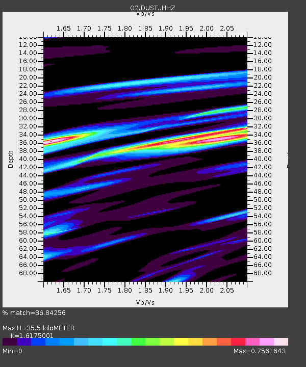
| Estimated Moho Depth: |
35.5 km |
| Estimated Crust Vp/Vs: |
1.62 |
| Assumed Crust Vp: |
6.426 km/s |
| Estimated Crust Vs: |
3.973 km/s |
| Estimated Crust Poisson's Ratio: |
0.19 |
|
| Radial Match: |
86.84256 % |
| Radial Bump: |
383 |
| Transverse Match: |
72.29433 % |
| Transverse Bump: |
400 |
| SOD ConfigId: |
29756493 |
| Insert Time: |
2022-11-25 11:17:06.539 +0000 |
| GWidth: |
2.5 |
| Max Bumps: |
400 |
| Tol: |
0.001 |
|

Signal To Noise
| Channel | StoN | STA | LTA |
| O2:DUST: :HHZ:20221111T11:01:11.459971Z | 25.315432 | 6.2234258E-6 | 2.4583525E-7 |
| O2:DUST: :HHN:20221111T11:01:11.459971Z | 3.767332 | 1.3487576E-6 | 3.5801398E-7 |
| O2:DUST: :HHE:20221111T11:01:11.459971Z | 1.5706017 | 2.669996E-6 | 1.6999828E-6 |
| Arrivals |
| Ps | 3.5 SECOND |
| PpPs | 14 SECOND |
| PsPs/PpSs | 18 SECOND |


