You are here: Home > Network List > O2 - Oklahoma Consolidated Temporary Seismic Networks Stations List
> Station FW01 Cuddy Creek, Oklahoma, USA > Earthquake Result Viewer
FW01 Cuddy Creek, Oklahoma, USA - Earthquake Result Viewer
| Earthquake location: |
Tonga Islands Region |
| Earthquake latitude/longitude: |
-19.3/-172.1 |
| Earthquake time(UTC): |
2022/11/11 (315) 10:48:45 GMT |
| Earthquake Depth: |
25 km |
| Earthquake Magnitude: |
7.3 Mww |
| Earthquake Catalog/Contributor: |
NEIC PDE/us |
|
| Network: |
O2 Oklahoma Consolidated Temporary Seismic Networks |
| Station: |
FW01 Cuddy Creek, Oklahoma, USA |
| Lat/Lon: |
36.49 N/98.94 W |
| Elevation: |
431 m |
|
| Distance: |
88.5 deg |
| Az: |
50.49 deg |
| Baz: |
244.714 deg |
| Ray Param: |
0.042495795 |
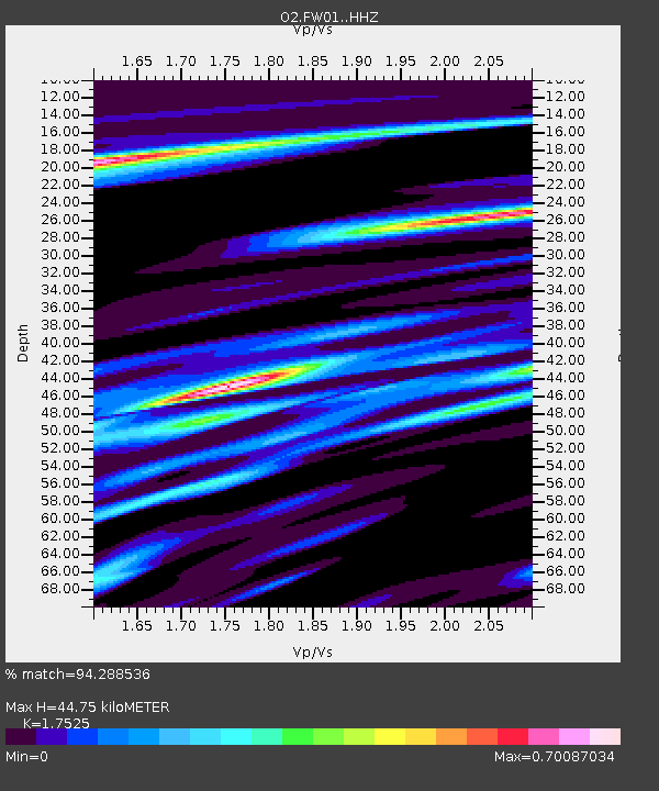
| Estimated Moho Depth: |
44.75 km |
| Estimated Crust Vp/Vs: |
1.75 |
| Assumed Crust Vp: |
6.426 km/s |
| Estimated Crust Vs: |
3.667 km/s |
| Estimated Crust Poisson's Ratio: |
0.26 |
|
| Radial Match: |
94.288536 % |
| Radial Bump: |
288 |
| Transverse Match: |
85.31061 % |
| Transverse Bump: |
363 |
| SOD ConfigId: |
29756493 |
| Insert Time: |
2022-11-25 11:17:11.491 +0000 |
| GWidth: |
2.5 |
| Max Bumps: |
400 |
| Tol: |
0.001 |
|

Signal To Noise
| Channel | StoN | STA | LTA |
| O2:FW01: :HHZ:20221111T11:01:04.034983Z | 38.76622 | 6.7283863E-6 | 1.7356312E-7 |
| O2:FW01: :HHN:20221111T11:01:04.034983Z | 3.8260665 | 1.3002607E-6 | 3.3984267E-7 |
| O2:FW01: :HHE:20221111T11:01:04.034983Z | 8.233443 | 2.1488913E-6 | 2.6099545E-7 |
| Arrivals |
| Ps | 5.4 SECOND |
| PpPs | 19 SECOND |
| PsPs/PpSs | 24 SECOND |


