You are here: Home > Network List > O2 - Oklahoma Consolidated Temporary Seismic Networks Stations List
> Station PW17 Maramec, Oklahoma,USA > Earthquake Result Viewer
PW17 Maramec, Oklahoma,USA - Earthquake Result Viewer
| Earthquake location: |
Tonga Islands Region |
| Earthquake latitude/longitude: |
-19.3/-172.1 |
| Earthquake time(UTC): |
2022/11/11 (315) 10:48:45 GMT |
| Earthquake Depth: |
25 km |
| Earthquake Magnitude: |
7.3 Mww |
| Earthquake Catalog/Contributor: |
NEIC PDE/us |
|
| Network: |
O2 Oklahoma Consolidated Temporary Seismic Networks |
| Station: |
PW17 Maramec, Oklahoma,USA |
| Lat/Lon: |
36.25 N/96.70 W |
| Elevation: |
324 m |
|
| Distance: |
90.1 deg |
| Az: |
51.47 deg |
| Baz: |
246.049 deg |
| Ray Param: |
0.04172223 |
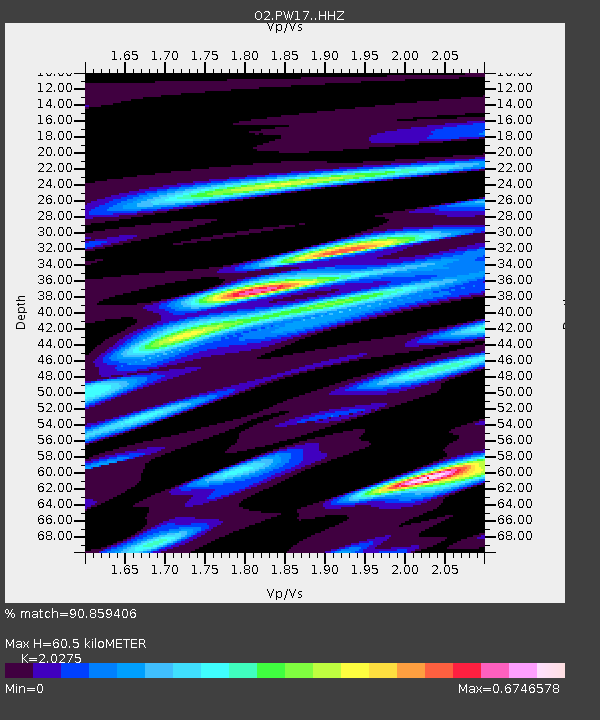
| Estimated Moho Depth: |
60.5 km |
| Estimated Crust Vp/Vs: |
2.03 |
| Assumed Crust Vp: |
6.483 km/s |
| Estimated Crust Vs: |
3.197 km/s |
| Estimated Crust Poisson's Ratio: |
0.34 |
|
| Radial Match: |
90.859406 % |
| Radial Bump: |
315 |
| Transverse Match: |
77.90442 % |
| Transverse Bump: |
400 |
| SOD ConfigId: |
29756493 |
| Insert Time: |
2022-11-25 11:17:50.542 +0000 |
| GWidth: |
2.5 |
| Max Bumps: |
400 |
| Tol: |
0.001 |
|

Signal To Noise
| Channel | StoN | STA | LTA |
| O2:PW17: :HHZ:20221111T11:01:11.219981Z | 30.788956 | 5.7862353E-6 | 1.8793217E-7 |
| O2:PW17: :HHN:20221111T11:01:11.219981Z | 1.1374462 | 8.182379E-7 | 7.193641E-7 |
| O2:PW17: :HHE:20221111T11:01:11.219981Z | 4.702462 | 2.440315E-6 | 5.1894415E-7 |
| Arrivals |
| Ps | 9.8 SECOND |
| PpPs | 28 SECOND |
| PsPs/PpSs | 38 SECOND |


