You are here: Home > Network List > TA - USArray Transportable Network (new EarthScope stations) Stations List
> Station Z25A Roswell, NM, USA > Earthquake Result Viewer
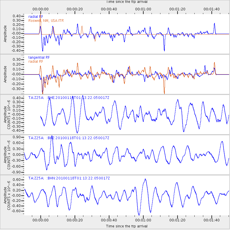
Z25A Roswell, NM, USA - Earthquake Result Viewer
*The percent match for this event was below the threshold and hence no stack was calculated.
| Earthquake location: |
Kuril Islands |
| Earthquake latitude/longitude: |
46.5/153.3 |
| Earthquake time(UTC): |
2010/01/18 (018) 01:02:16 GMT |
| Earthquake Depth: |
7.0 km |
| Earthquake Magnitude: |
5.6 MB, 5.3 MS, 5.6 MW, 5.6 MW |
| Earthquake Catalog/Contributor: |
WHDF/NEIC |
|
| Network: |
TA USArray Transportable Network (new EarthScope stations) |
| Station: |
Z25A Roswell, NM, USA |
| Lat/Lon: |
33.28 N/104.72 W |
| Elevation: |
1233 m |
|
| Distance: |
74.1 deg |
| Az: |
58.427 deg |
| Baz: |
315.348 deg |
| Ray Param: |
$rayparam |
*The percent match for this event was below the threshold and hence was not used in the summary stack. |
|
| Radial Match: |
72.36206 % |
| Radial Bump: |
400 |
| Transverse Match: |
64.7143 % |
| Transverse Bump: |
400 |
| SOD ConfigId: |
296938 |
| Insert Time: |
2010-04-06 21:13:22.733 +0000 |
| GWidth: |
2.5 |
| Max Bumps: |
400 |
| Tol: |
0.001 |
|
Signal To Noise
| Channel | StoN | STA | LTA |
| TA:Z25A: :BHZ:20100118T01:13:22.050017Z | 2.098785 | 3.995333E-7 | 1.9036408E-7 |
| TA:Z25A: :BHN:20100118T01:13:22.050017Z | 1.6210167 | 2.191089E-7 | 1.3516757E-7 |
| TA:Z25A: :BHE:20100118T01:13:22.050017Z | 0.27629003 | 6.3388114E-8 | 2.2942599E-7 |
| Arrivals |
| Ps | |
| PpPs | |
| PsPs/PpSs | |


