You are here: Home > Network List > O2 - Oklahoma Consolidated Temporary Seismic Networks Stations List
> Station WADE Ringling, Oklahoma, USA > Earthquake Result Viewer
WADE Ringling, Oklahoma, USA - Earthquake Result Viewer
| Earthquake location: |
Tonga Islands Region |
| Earthquake latitude/longitude: |
-19.3/-172.1 |
| Earthquake time(UTC): |
2022/11/11 (315) 10:48:45 GMT |
| Earthquake Depth: |
25 km |
| Earthquake Magnitude: |
7.3 Mww |
| Earthquake Catalog/Contributor: |
NEIC PDE/us |
|
| Network: |
O2 Oklahoma Consolidated Temporary Seismic Networks |
| Station: |
WADE Ringling, Oklahoma, USA |
| Lat/Lon: |
34.15 N/97.62 W |
| Elevation: |
268 m |
|
| Distance: |
88.5 deg |
| Az: |
53.069 deg |
| Baz: |
245.541 deg |
| Ray Param: |
0.042498685 |
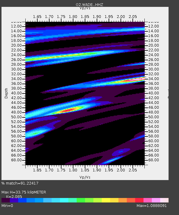
| Estimated Moho Depth: |
33.75 km |
| Estimated Crust Vp/Vs: |
2.09 |
| Assumed Crust Vp: |
6.426 km/s |
| Estimated Crust Vs: |
3.082 km/s |
| Estimated Crust Poisson's Ratio: |
0.35 |
|
| Radial Match: |
91.22417 % |
| Radial Bump: |
400 |
| Transverse Match: |
89.06206 % |
| Transverse Bump: |
400 |
| SOD ConfigId: |
29756493 |
| Insert Time: |
2022-11-25 11:18:39.820 +0000 |
| GWidth: |
2.5 |
| Max Bumps: |
400 |
| Tol: |
0.001 |
|

Signal To Noise
| Channel | StoN | STA | LTA |
| O2:WADE: :HHZ:20221111T11:01:04.015025Z | 33.46606 | 1.02346785E-5 | 3.0582265E-7 |
| O2:WADE: :HHN:20221111T11:01:04.015025Z | 0.90180796 | 1.8572221E-6 | 2.059443E-6 |
| O2:WADE: :HHE:20221111T11:01:04.015025Z | 2.0115144 | 2.6813009E-6 | 1.3329762E-6 |
| Arrivals |
| Ps | 5.8 SECOND |
| PpPs | 16 SECOND |
| PsPs/PpSs | 22 SECOND |


