You are here: Home > Network List > TA - USArray Transportable Network (new EarthScope stations) Stations List
> Station M24A Cheyenne, WY, USA > Earthquake Result Viewer
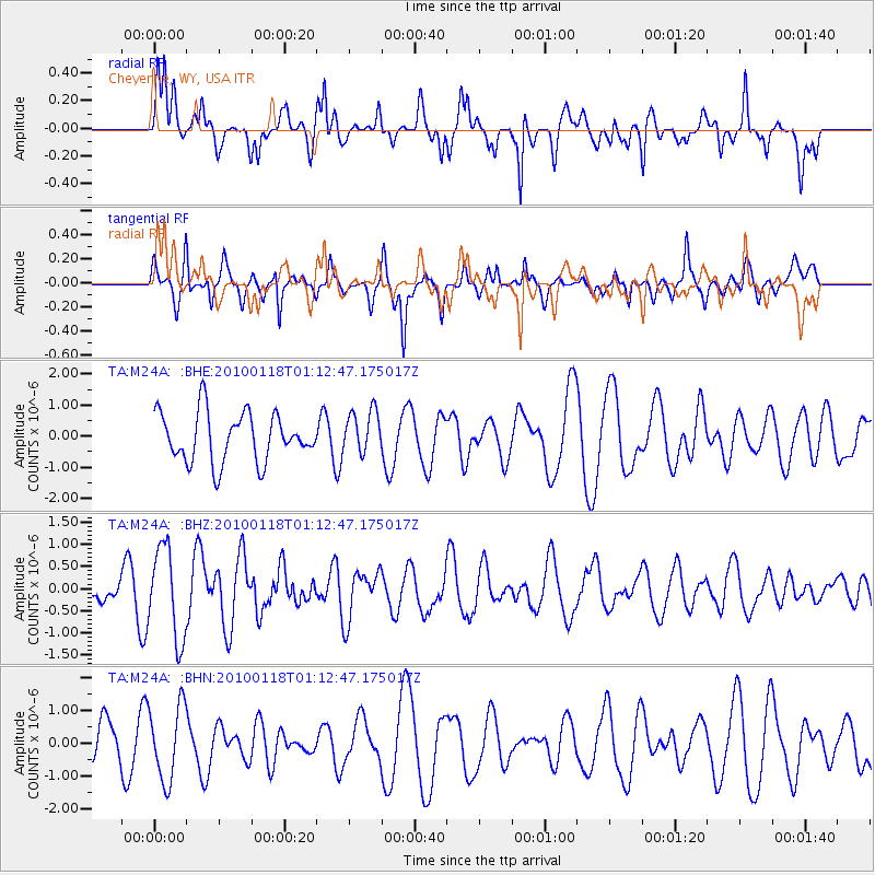
M24A Cheyenne, WY, USA - Earthquake Result Viewer
*The percent match for this event was below the threshold and hence no stack was calculated.
| Earthquake location: |
Kuril Islands |
| Earthquake latitude/longitude: |
46.5/153.3 |
| Earthquake time(UTC): |
2010/01/18 (018) 01:02:16 GMT |
| Earthquake Depth: |
7.0 km |
| Earthquake Magnitude: |
5.6 MB, 5.3 MS, 5.6 MW, 5.6 MW |
| Earthquake Catalog/Contributor: |
WHDF/NEIC |
|
| Network: |
TA USArray Transportable Network (new EarthScope stations) |
| Station: |
M24A Cheyenne, WY, USA |
| Lat/Lon: |
41.47 N/104.82 W |
| Elevation: |
1816 m |
|
| Distance: |
68.3 deg |
| Az: |
52.317 deg |
| Baz: |
313.309 deg |
| Ray Param: |
$rayparam |
*The percent match for this event was below the threshold and hence was not used in the summary stack. |
|
| Radial Match: |
60.20591 % |
| Radial Bump: |
380 |
| Transverse Match: |
61.97832 % |
| Transverse Bump: |
356 |
| SOD ConfigId: |
296938 |
| Insert Time: |
2010-04-06 21:14:01.075 +0000 |
| GWidth: |
2.5 |
| Max Bumps: |
400 |
| Tol: |
0.001 |
|
Signal To Noise
| Channel | StoN | STA | LTA |
| TA:M24A: :BHZ:20100118T01:12:47.175017Z | 3.5585568 | 1.02629E-6 | 2.8840063E-7 |
| TA:M24A: :BHN:20100118T01:12:47.175017Z | 1.8446391 | 1.1373074E-6 | 6.165474E-7 |
| TA:M24A: :BHE:20100118T01:12:47.175017Z | 0.88831216 | 6.953757E-7 | 7.828056E-7 |
| Arrivals |
| Ps | |
| PpPs | |
| PsPs/PpSs | |


