You are here: Home > Network List > OK - Oklahoma Seismic Network Stations List
> Station MOOR Moore, Oklahoma, USA > Earthquake Result Viewer
MOOR Moore, Oklahoma, USA - Earthquake Result Viewer
| Earthquake location: |
Tonga Islands Region |
| Earthquake latitude/longitude: |
-19.3/-172.1 |
| Earthquake time(UTC): |
2022/11/11 (315) 10:48:45 GMT |
| Earthquake Depth: |
25 km |
| Earthquake Magnitude: |
7.3 Mww |
| Earthquake Catalog/Contributor: |
NEIC PDE/us |
|
| Network: |
OK Oklahoma Seismic Network |
| Station: |
MOOR Moore, Oklahoma, USA |
| Lat/Lon: |
35.34 N/97.66 W |
| Elevation: |
371 m |
|
| Distance: |
89.0 deg |
| Az: |
51.972 deg |
| Baz: |
245.495 deg |
| Ray Param: |
0.042161398 |
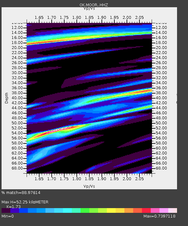
| Estimated Moho Depth: |
52.25 km |
| Estimated Crust Vp/Vs: |
1.73 |
| Assumed Crust Vp: |
6.426 km/s |
| Estimated Crust Vs: |
3.715 km/s |
| Estimated Crust Poisson's Ratio: |
0.25 |
|
| Radial Match: |
88.97614 % |
| Radial Bump: |
389 |
| Transverse Match: |
86.351654 % |
| Transverse Bump: |
400 |
| SOD ConfigId: |
29756493 |
| Insert Time: |
2022-11-25 11:19:01.854 +0000 |
| GWidth: |
2.5 |
| Max Bumps: |
400 |
| Tol: |
0.001 |
|

Signal To Noise
| Channel | StoN | STA | LTA |
| OK:MOOR: :HHZ:20221111T11:01:06.190013Z | 18.70999 | 7.82706E-6 | 4.1833584E-7 |
| OK:MOOR: :HHN:20221111T11:01:06.190013Z | 1.1453484 | 8.072684E-7 | 7.0482344E-7 |
| OK:MOOR: :HHE:20221111T11:01:06.190013Z | 1.9503745 | 1.5926458E-6 | 8.1658465E-7 |
| Arrivals |
| Ps | 6.1 SECOND |
| PpPs | 22 SECOND |
| PsPs/PpSs | 28 SECOND |


