You are here: Home > Network List > TA - USArray Transportable Network (new EarthScope stations) Stations List
> Station D22A Cohagen, MT, USA > Earthquake Result Viewer
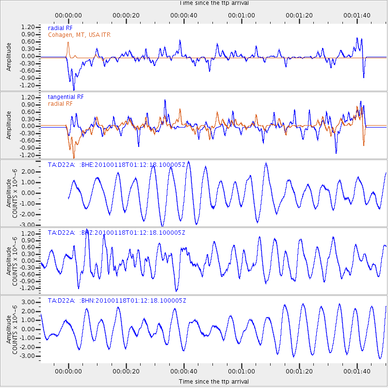
D22A Cohagen, MT, USA - Earthquake Result Viewer
*The percent match for this event was below the threshold and hence no stack was calculated.
| Earthquake location: |
Kuril Islands |
| Earthquake latitude/longitude: |
46.5/153.3 |
| Earthquake time(UTC): |
2010/01/18 (018) 01:02:16 GMT |
| Earthquake Depth: |
7.0 km |
| Earthquake Magnitude: |
5.6 MB, 5.3 MS, 5.6 MW, 5.6 MW |
| Earthquake Catalog/Contributor: |
WHDF/NEIC |
|
| Network: |
TA USArray Transportable Network (new EarthScope stations) |
| Station: |
D22A Cohagen, MT, USA |
| Lat/Lon: |
47.15 N/106.18 W |
| Elevation: |
791 m |
|
| Distance: |
63.8 deg |
| Az: |
48.414 deg |
| Baz: |
310.778 deg |
| Ray Param: |
$rayparam |
*The percent match for this event was below the threshold and hence was not used in the summary stack. |
|
| Radial Match: |
65.694664 % |
| Radial Bump: |
400 |
| Transverse Match: |
53.566563 % |
| Transverse Bump: |
368 |
| SOD ConfigId: |
296938 |
| Insert Time: |
2010-04-06 21:14:44.810 +0000 |
| GWidth: |
2.5 |
| Max Bumps: |
400 |
| Tol: |
0.001 |
|
Signal To Noise
| Channel | StoN | STA | LTA |
| TA:D22A: :BHZ:20100118T01:12:18.100005Z | 2.4481072 | 5.2418613E-7 | 2.1411896E-7 |
| TA:D22A: :BHN:20100118T01:12:18.100005Z | 0.62449926 | 1.177577E-6 | 1.885634E-6 |
| TA:D22A: :BHE:20100118T01:12:18.100005Z | 1.9564853 | 2.040623E-6 | 1.0430045E-6 |
| Arrivals |
| Ps | |
| PpPs | |
| PsPs/PpSs | |


