You are here: Home > Network List > PQ - Public Safety Geoscience Program Canadian Research Network (PSGP) Stations List
> Station ALBHB Albert Head, Victoria, BC, Canada > Earthquake Result Viewer
ALBHB Albert Head, Victoria, BC, Canada - Earthquake Result Viewer
| Earthquake location: |
Tonga Islands Region |
| Earthquake latitude/longitude: |
-19.3/-172.1 |
| Earthquake time(UTC): |
2022/11/11 (315) 10:48:45 GMT |
| Earthquake Depth: |
25 km |
| Earthquake Magnitude: |
7.3 Mww |
| Earthquake Catalog/Contributor: |
NEIC PDE/us |
|
| Network: |
PQ Public Safety Geoscience Program Canadian Research Network (PSGP) |
| Station: |
ALBHB Albert Head, Victoria, BC, Canada |
| Lat/Lon: |
48.39 N/123.49 W |
| Elevation: |
40 m |
|
| Distance: |
80.2 deg |
| Az: |
30.502 deg |
| Baz: |
225.983 deg |
| Ray Param: |
0.048450682 |
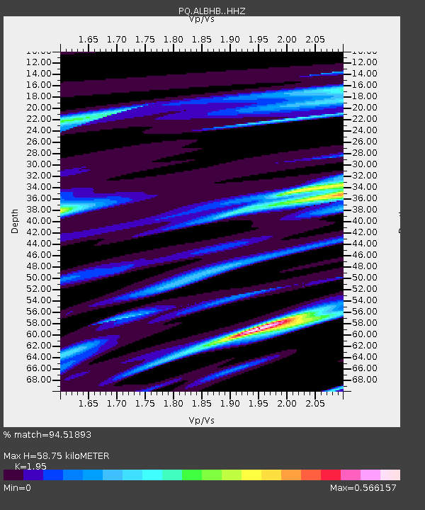
| Estimated Moho Depth: |
58.75 km |
| Estimated Crust Vp/Vs: |
1.95 |
| Assumed Crust Vp: |
6.566 km/s |
| Estimated Crust Vs: |
3.367 km/s |
| Estimated Crust Poisson's Ratio: |
0.32 |
|
| Radial Match: |
94.51893 % |
| Radial Bump: |
266 |
| Transverse Match: |
81.20535 % |
| Transverse Bump: |
366 |
| SOD ConfigId: |
29756493 |
| Insert Time: |
2022-11-25 11:20:44.157 +0000 |
| GWidth: |
2.5 |
| Max Bumps: |
400 |
| Tol: |
0.001 |
|

Signal To Noise
| Channel | StoN | STA | LTA |
| PQ:ALBHB: :HHZ:20221111T11:00:21.76002Z | 9.799731 | 6.0745115E-6 | 6.198651E-7 |
| PQ:ALBHB: :HHN:20221111T11:00:21.76002Z | 3.6563797 | 1.6587173E-6 | 4.5365022E-7 |
| PQ:ALBHB: :HHE:20221111T11:00:21.76002Z | 4.1502867 | 1.8809827E-6 | 4.5321755E-7 |
| Arrivals |
| Ps | 8.7 SECOND |
| PpPs | 26 SECOND |
| PsPs/PpSs | 34 SECOND |


