You are here: Home > Network List > PQ - Public Safety Geoscience Program Canadian Research Network (PSGP) Stations List
> Station ULUN Ulukhaktok, Victoria Island, NWT, Canada > Earthquake Result Viewer
ULUN Ulukhaktok, Victoria Island, NWT, Canada - Earthquake Result Viewer
| Earthquake location: |
Tonga Islands Region |
| Earthquake latitude/longitude: |
-19.3/-172.1 |
| Earthquake time(UTC): |
2022/11/11 (315) 10:48:45 GMT |
| Earthquake Depth: |
25 km |
| Earthquake Magnitude: |
7.3 Mww |
| Earthquake Catalog/Contributor: |
NEIC PDE/us |
|
| Network: |
PQ Public Safety Geoscience Program Canadian Research Network (PSGP) |
| Station: |
ULUN Ulukhaktok, Victoria Island, NWT, Canada |
| Lat/Lon: |
70.74 N/117.76 W |
| Elevation: |
5.0 m |
|
| Distance: |
97.3 deg |
| Az: |
15.776 deg |
| Baz: |
230.678 deg |
| Ray Param: |
0.040242746 |
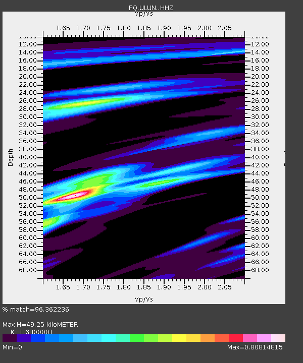
| Estimated Moho Depth: |
49.25 km |
| Estimated Crust Vp/Vs: |
1.68 |
| Assumed Crust Vp: |
6.367 km/s |
| Estimated Crust Vs: |
3.79 km/s |
| Estimated Crust Poisson's Ratio: |
0.23 |
|
| Radial Match: |
96.362236 % |
| Radial Bump: |
314 |
| Transverse Match: |
77.16651 % |
| Transverse Bump: |
400 |
| SOD ConfigId: |
29756493 |
| Insert Time: |
2022-11-25 11:20:47.198 +0000 |
| GWidth: |
2.5 |
| Max Bumps: |
400 |
| Tol: |
0.001 |
|

Signal To Noise
| Channel | StoN | STA | LTA |
| PQ:ULUN: :HHZ:20221111T11:01:44.339976Z | 9.797898 | 2.907857E-6 | 2.9678375E-7 |
| PQ:ULUN: :HHN:20221111T11:01:44.339976Z | 3.835587 | 6.795497E-7 | 1.7716968E-7 |
| PQ:ULUN: :HHE:20221111T11:01:44.339976Z | 3.5586488 | 8.365785E-7 | 2.3508318E-7 |
| Arrivals |
| Ps | 5.4 SECOND |
| PpPs | 20 SECOND |
| PsPs/PpSs | 26 SECOND |


