You are here: Home > Network List > TA - USArray Transportable Network (new EarthScope stations) Stations List
> Station SFIN Lafayette, IN, USA > Earthquake Result Viewer
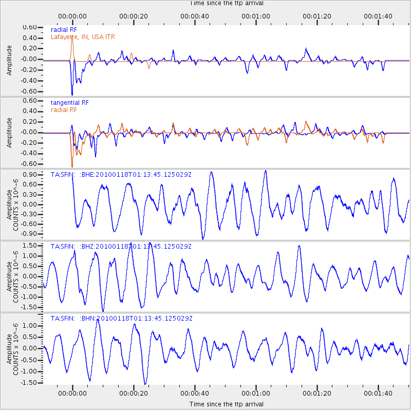
SFIN Lafayette, IN, USA - Earthquake Result Viewer
*The percent match for this event was below the threshold and hence no stack was calculated.
| Earthquake location: |
Kuril Islands |
| Earthquake latitude/longitude: |
46.5/153.3 |
| Earthquake time(UTC): |
2010/01/18 (018) 01:02:16 GMT |
| Earthquake Depth: |
7.0 km |
| Earthquake Magnitude: |
5.6 MB, 5.3 MS, 5.6 MW, 5.6 MW |
| Earthquake Catalog/Contributor: |
WHDF/NEIC |
|
| Network: |
TA USArray Transportable Network (new EarthScope stations) |
| Station: |
SFIN Lafayette, IN, USA |
| Lat/Lon: |
40.38 N/87.10 W |
| Elevation: |
165 m |
|
| Distance: |
78.1 deg |
| Az: |
42.72 deg |
| Baz: |
322.145 deg |
| Ray Param: |
$rayparam |
*The percent match for this event was below the threshold and hence was not used in the summary stack. |
|
| Radial Match: |
68.90847 % |
| Radial Bump: |
400 |
| Transverse Match: |
82.51571 % |
| Transverse Bump: |
400 |
| SOD ConfigId: |
296938 |
| Insert Time: |
2010-04-06 21:15:04.311 +0000 |
| GWidth: |
2.5 |
| Max Bumps: |
400 |
| Tol: |
0.001 |
|
Signal To Noise
| Channel | StoN | STA | LTA |
| TA:SFIN: :BHZ:20100118T01:13:45.125029Z | 1.7983674 | 8.6834996E-7 | 4.8285455E-7 |
| TA:SFIN: :BHN:20100118T01:13:45.125029Z | 1.5542803 | 4.73113E-7 | 3.0439364E-7 |
| TA:SFIN: :BHE:20100118T01:13:45.125029Z | 0.78369594 | 3.5704377E-7 | 4.5558969E-7 |
| Arrivals |
| Ps | |
| PpPs | |
| PsPs/PpSs | |


