You are here: Home > Network List > RM - Regional Integrated Multi Hazard Early Warning System Stations List
> Station SLV Son La Vietnam > Earthquake Result Viewer
SLV Son La Vietnam - Earthquake Result Viewer
| Earthquake location: |
Tonga Islands Region |
| Earthquake latitude/longitude: |
-19.3/-172.1 |
| Earthquake time(UTC): |
2022/11/11 (315) 10:48:45 GMT |
| Earthquake Depth: |
25 km |
| Earthquake Magnitude: |
7.3 Mww |
| Earthquake Catalog/Contributor: |
NEIC PDE/us |
|
| Network: |
RM Regional Integrated Multi Hazard Early Warning System |
| Station: |
SLV Son La Vietnam |
| Lat/Lon: |
21.33 N/103.91 E |
| Elevation: |
630 m |
|
| Distance: |
91.5 deg |
| Az: |
291.941 deg |
| Baz: |
110.026 deg |
| Ray Param: |
0.04159086 |
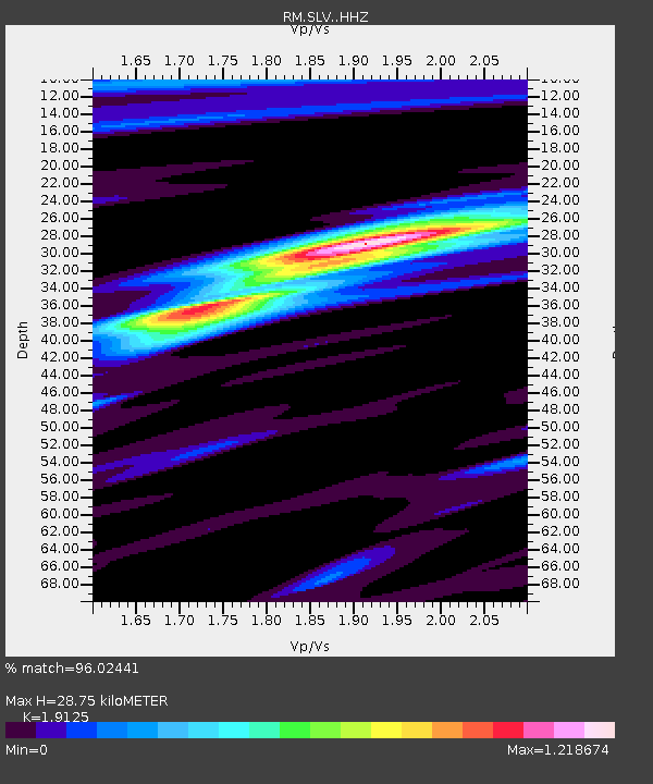
| Estimated Moho Depth: |
28.75 km |
| Estimated Crust Vp/Vs: |
1.91 |
| Assumed Crust Vp: |
6.35 km/s |
| Estimated Crust Vs: |
3.32 km/s |
| Estimated Crust Poisson's Ratio: |
0.31 |
|
| Radial Match: |
96.02441 % |
| Radial Bump: |
400 |
| Transverse Match: |
95.74958 % |
| Transverse Bump: |
400 |
| SOD ConfigId: |
29756493 |
| Insert Time: |
2022-11-25 11:21:39.365 +0000 |
| GWidth: |
2.5 |
| Max Bumps: |
400 |
| Tol: |
0.001 |
|

Signal To Noise
| Channel | StoN | STA | LTA |
| RM:SLV: :HHZ:20221111T11:01:17.997996Z | 38.500416 | 2.6488112E-6 | 6.8799544E-8 |
| RM:SLV: :HHN:20221111T11:01:17.997996Z | 3.314887 | 1.04572955E-7 | 3.154646E-8 |
| RM:SLV: :HHE:20221111T11:01:17.997996Z | 17.696636 | 7.4218764E-7 | 4.1939472E-8 |
| Arrivals |
| Ps | 4.2 SECOND |
| PpPs | 13 SECOND |
| PsPs/PpSs | 17 SECOND |


