You are here: Home > Network List > TA - USArray Transportable Network (new EarthScope stations) Stations List
> Station 532A Rocksprings, TX, USA > Earthquake Result Viewer
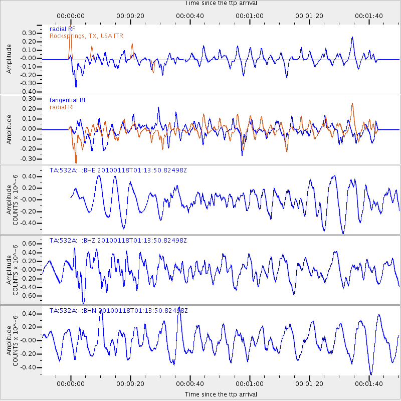
532A Rocksprings, TX, USA - Earthquake Result Viewer
*The percent match for this event was below the threshold and hence no stack was calculated.
| Earthquake location: |
Kuril Islands |
| Earthquake latitude/longitude: |
46.5/153.3 |
| Earthquake time(UTC): |
2010/01/18 (018) 01:02:16 GMT |
| Earthquake Depth: |
7.0 km |
| Earthquake Magnitude: |
5.6 MB, 5.3 MS, 5.6 MW, 5.6 MW |
| Earthquake Catalog/Contributor: |
WHDF/NEIC |
|
| Network: |
TA USArray Transportable Network (new EarthScope stations) |
| Station: |
532A Rocksprings, TX, USA |
| Lat/Lon: |
30.13 N/99.90 W |
| Elevation: |
703 m |
|
| Distance: |
79.2 deg |
| Az: |
57.59 deg |
| Baz: |
317.673 deg |
| Ray Param: |
$rayparam |
*The percent match for this event was below the threshold and hence was not used in the summary stack. |
|
| Radial Match: |
49.383797 % |
| Radial Bump: |
384 |
| Transverse Match: |
67.91537 % |
| Transverse Bump: |
400 |
| SOD ConfigId: |
296938 |
| Insert Time: |
2010-04-06 21:16:02.430 +0000 |
| GWidth: |
2.5 |
| Max Bumps: |
400 |
| Tol: |
0.001 |
|
Signal To Noise
| Channel | StoN | STA | LTA |
| TA:532A: :BHZ:20100118T01:13:50.82498Z | 2.0018766 | 3.5882854E-7 | 1.7924609E-7 |
| TA:532A: :BHN:20100118T01:13:50.82498Z | 0.77654773 | 1.3882786E-7 | 1.7877571E-7 |
| TA:532A: :BHE:20100118T01:13:50.82498Z | 0.74523115 | 1.6784854E-7 | 2.2523017E-7 |
| Arrivals |
| Ps | |
| PpPs | |
| PsPs/PpSs | |


