You are here: Home > Network List > TX - Texas Seismological Network Stations List
> Station PB08 Permian Basin 08 > Earthquake Result Viewer
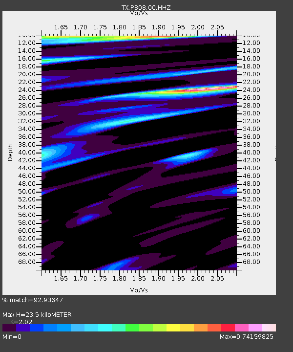
PB08 Permian Basin 08 - Earthquake Result Viewer
| Earthquake location: |
Tonga Islands Region |
| Earthquake latitude/longitude: |
-19.3/-172.1 |
| Earthquake time(UTC): |
2022/11/11 (315) 10:48:45 GMT |
| Earthquake Depth: |
25 km |
| Earthquake Magnitude: |
7.3 Mww |
| Earthquake Catalog/Contributor: |
NEIC PDE/us |
|
| Network: |
TX Texas Seismological Network |
| Station: |
PB08 Permian Basin 08 |
| Lat/Lon: |
30.89 N/102.91 W |
| Elevation: |
926 m |
|
| Distance: |
83.1 deg |
| Az: |
54.045 deg |
| Baz: |
242.781 deg |
| Ray Param: |
0.046412118 |
| Estimated Moho Depth: |
23.5 km |
| Estimated Crust Vp/Vs: |
2.02 |
| Assumed Crust Vp: |
6.121 km/s |
| Estimated Crust Vs: |
3.03 km/s |
| Estimated Crust Poisson's Ratio: |
0.34 |
|
| Radial Match: |
92.93647 % |
| Radial Bump: |
400 |
| Transverse Match: |
84.14709 % |
| Transverse Bump: |
400 |
| SOD ConfigId: |
29756493 |
| Insert Time: |
2022-11-25 11:25:41.385 +0000 |
| GWidth: |
2.5 |
| Max Bumps: |
400 |
| Tol: |
0.001 |
|

Signal To Noise
| Channel | StoN | STA | LTA |
| TX:PB08:00:HHZ:20221111T11:00:37.190013Z | 24.653599 | 3.5150258E-6 | 1.4257658E-7 |
| TX:PB08:00:HH1:20221111T11:00:37.190013Z | 5.078452 | 5.922015E-7 | 1.16610636E-7 |
| TX:PB08:00:HH2:20221111T11:00:37.190013Z | 2.9943469 | 5.639542E-7 | 1.8833964E-7 |
| Arrivals |
| Ps | 4.0 SECOND |
| PpPs | 11 SECOND |
| PsPs/PpSs | 15 SECOND |


