You are here: Home > Network List > TX - Texas Seismological Network Stations List
> Station PB10 Southeast of Toyah > Earthquake Result Viewer
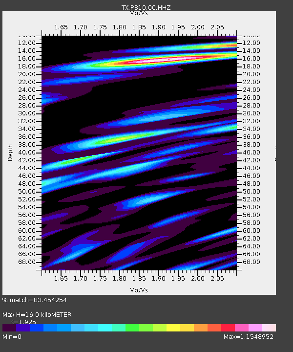
PB10 Southeast of Toyah - Earthquake Result Viewer
| Earthquake location: |
Tonga Islands Region |
| Earthquake latitude/longitude: |
-19.3/-172.1 |
| Earthquake time(UTC): |
2022/11/11 (315) 10:48:45 GMT |
| Earthquake Depth: |
25 km |
| Earthquake Magnitude: |
7.3 Mww |
| Earthquake Catalog/Contributor: |
NEIC PDE/us |
|
| Network: |
TX Texas Seismological Network |
| Station: |
PB10 Southeast of Toyah |
| Lat/Lon: |
31.28 N/103.75 W |
| Elevation: |
858 m |
|
| Distance: |
82.6 deg |
| Az: |
53.357 deg |
| Baz: |
242.26 deg |
| Ray Param: |
0.0467383 |
| Estimated Moho Depth: |
16.0 km |
| Estimated Crust Vp/Vs: |
1.92 |
| Assumed Crust Vp: |
6.121 km/s |
| Estimated Crust Vs: |
3.179 km/s |
| Estimated Crust Poisson's Ratio: |
0.32 |
|
| Radial Match: |
83.454254 % |
| Radial Bump: |
400 |
| Transverse Match: |
70.13039 % |
| Transverse Bump: |
400 |
| SOD ConfigId: |
29756493 |
| Insert Time: |
2022-11-25 11:25:41.742 +0000 |
| GWidth: |
2.5 |
| Max Bumps: |
400 |
| Tol: |
0.001 |
|

Signal To Noise
| Channel | StoN | STA | LTA |
| TX:PB10:00:HHZ:20221111T11:00:34.789988Z | 24.01193 | 5.2268065E-6 | 2.1767539E-7 |
| TX:PB10:00:HH1:20221111T11:00:34.789988Z | 6.8278937 | 1.2918591E-6 | 1.8920316E-7 |
| TX:PB10:00:HH2:20221111T11:00:34.789988Z | 6.9300537 | 1.9713352E-6 | 2.8446172E-7 |
| Arrivals |
| Ps | 2.5 SECOND |
| PpPs | 7.5 SECOND |
| PsPs/PpSs | 10.0 SECOND |


