You are here: Home > Network List > TX - Texas Seismological Network Stations List
> Station PB16 Coyonosa > Earthquake Result Viewer
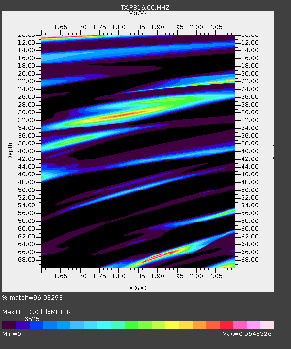
PB16 Coyonosa - Earthquake Result Viewer
| Earthquake location: |
Tonga Islands Region |
| Earthquake latitude/longitude: |
-19.3/-172.1 |
| Earthquake time(UTC): |
2022/11/11 (315) 10:48:45 GMT |
| Earthquake Depth: |
25 km |
| Earthquake Magnitude: |
7.3 Mww |
| Earthquake Catalog/Contributor: |
NEIC PDE/us |
|
| Network: |
TX Texas Seismological Network |
| Station: |
PB16 Coyonosa |
| Lat/Lon: |
31.12 N/103.25 W |
| Elevation: |
848 m |
|
| Distance: |
82.9 deg |
| Az: |
53.7 deg |
| Baz: |
242.562 deg |
| Ray Param: |
0.04652303 |
| Estimated Moho Depth: |
10.0 km |
| Estimated Crust Vp/Vs: |
1.65 |
| Assumed Crust Vp: |
6.121 km/s |
| Estimated Crust Vs: |
3.704 km/s |
| Estimated Crust Poisson's Ratio: |
0.21 |
|
| Radial Match: |
96.08293 % |
| Radial Bump: |
400 |
| Transverse Match: |
90.470375 % |
| Transverse Bump: |
400 |
| SOD ConfigId: |
29756493 |
| Insert Time: |
2022-11-25 11:25:50.201 +0000 |
| GWidth: |
2.5 |
| Max Bumps: |
400 |
| Tol: |
0.001 |
|

Signal To Noise
| Channel | StoN | STA | LTA |
| TX:PB16:00:HHZ:20221111T11:00:36.380015Z | 12.318819 | 5.1148127E-6 | 4.1520317E-7 |
| TX:PB16:00:HH1:20221111T11:00:36.380015Z | 2.443539 | 3.5687026E-7 | 1.4604647E-7 |
| TX:PB16:00:HH2:20221111T11:00:36.380015Z | 5.964191 | 1.0386085E-6 | 1.7414072E-7 |
| Arrivals |
| Ps | 1.1 SECOND |
| PpPs | 4.2 SECOND |
| PsPs/PpSs | 5.3 SECOND |


