You are here: Home > Network List > TX - Texas Seismological Network Stations List
> Station PB32 CR 111 > Earthquake Result Viewer
PB32 CR 111 - Earthquake Result Viewer
| Earthquake location: |
Tonga Islands Region |
| Earthquake latitude/longitude: |
-19.3/-172.1 |
| Earthquake time(UTC): |
2022/11/11 (315) 10:48:45 GMT |
| Earthquake Depth: |
25 km |
| Earthquake Magnitude: |
7.3 Mww |
| Earthquake Catalog/Contributor: |
NEIC PDE/us |
|
| Network: |
TX Texas Seismological Network |
| Station: |
PB32 CR 111 |
| Lat/Lon: |
31.10 N/103.37 W |
| Elevation: |
861 m |
|
| Distance: |
82.8 deg |
| Az: |
53.671 deg |
| Baz: |
242.496 deg |
| Ray Param: |
0.046594895 |
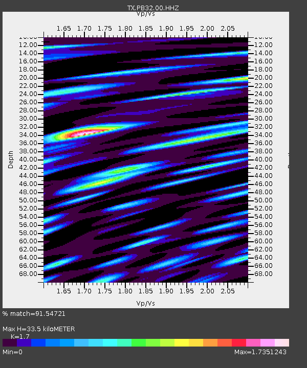
| Estimated Moho Depth: |
33.5 km |
| Estimated Crust Vp/Vs: |
1.70 |
| Assumed Crust Vp: |
6.121 km/s |
| Estimated Crust Vs: |
3.6 km/s |
| Estimated Crust Poisson's Ratio: |
0.24 |
|
| Radial Match: |
91.54721 % |
| Radial Bump: |
400 |
| Transverse Match: |
82.5596 % |
| Transverse Bump: |
400 |
| SOD ConfigId: |
29756493 |
| Insert Time: |
2022-11-25 11:26:03.397 +0000 |
| GWidth: |
2.5 |
| Max Bumps: |
400 |
| Tol: |
0.001 |
|

Signal To Noise
| Channel | StoN | STA | LTA |
| TX:PB32:00:HHZ:20221111T11:00:35.859996Z | 21.940031 | 3.652781E-7 | 1.6648933E-8 |
| TX:PB32:00:HH1:20221111T11:00:35.859996Z | 2.0271857 | 5.4622873E-8 | 2.6945175E-8 |
| TX:PB32:00:HH2:20221111T11:00:35.859996Z | 3.103148 | 9.340581E-8 | 3.0100338E-8 |
| Arrivals |
| Ps | 3.9 SECOND |
| PpPs | 14 SECOND |
| PsPs/PpSs | 18 SECOND |


