You are here: Home > Network List > TX - Texas Seismological Network Stations List
> Station PH03 Pantex > Earthquake Result Viewer
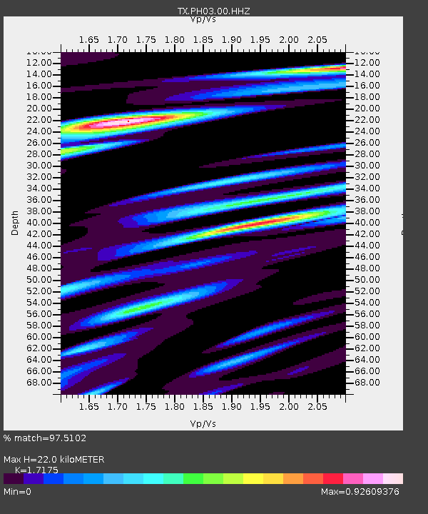
PH03 Pantex - Earthquake Result Viewer
| Earthquake location: |
Tonga Islands Region |
| Earthquake latitude/longitude: |
-19.3/-172.1 |
| Earthquake time(UTC): |
2022/11/11 (315) 10:48:45 GMT |
| Earthquake Depth: |
25 km |
| Earthquake Magnitude: |
7.3 Mww |
| Earthquake Catalog/Contributor: |
NEIC PDE/us |
|
| Network: |
TX Texas Seismological Network |
| Station: |
PH03 Pantex |
| Lat/Lon: |
35.36 N/101.55 W |
| Elevation: |
1061 m |
|
| Distance: |
86.1 deg |
| Az: |
50.579 deg |
| Baz: |
243.193 deg |
| Ray Param: |
0.044254374 |
| Estimated Moho Depth: |
22.0 km |
| Estimated Crust Vp/Vs: |
1.72 |
| Assumed Crust Vp: |
6.426 km/s |
| Estimated Crust Vs: |
3.742 km/s |
| Estimated Crust Poisson's Ratio: |
0.24 |
|
| Radial Match: |
97.5102 % |
| Radial Bump: |
352 |
| Transverse Match: |
93.97688 % |
| Transverse Bump: |
400 |
| SOD ConfigId: |
29756493 |
| Insert Time: |
2022-11-25 11:26:06.799 +0000 |
| GWidth: |
2.5 |
| Max Bumps: |
400 |
| Tol: |
0.001 |
|

Signal To Noise
| Channel | StoN | STA | LTA |
| TX:PH03:00:HHZ:20221111T11:00:52.469981Z | 26.757008 | 1.3568203E-5 | 5.0708974E-7 |
| TX:PH03:00:HH1:20221111T11:00:52.469981Z | 2.405623 | 1.6488012E-6 | 6.8539475E-7 |
| TX:PH03:00:HH2:20221111T11:00:52.469981Z | 3.3196576 | 2.6973612E-6 | 8.12542E-7 |
| Arrivals |
| Ps | 2.5 SECOND |
| PpPs | 9.1 SECOND |
| PsPs/PpSs | 12 SECOND |


