You are here: Home > Network List > TX - Texas Seismological Network Stations List
> Station SAND Sanderson > Earthquake Result Viewer
SAND Sanderson - Earthquake Result Viewer
| Earthquake location: |
Tonga Islands Region |
| Earthquake latitude/longitude: |
-19.3/-172.1 |
| Earthquake time(UTC): |
2022/11/11 (315) 10:48:45 GMT |
| Earthquake Depth: |
25 km |
| Earthquake Magnitude: |
7.3 Mww |
| Earthquake Catalog/Contributor: |
NEIC PDE/us |
|
| Network: |
TX Texas Seismological Network |
| Station: |
SAND Sanderson |
| Lat/Lon: |
29.95 N/102.12 W |
| Elevation: |
689 m |
|
| Distance: |
83.3 deg |
| Az: |
55.192 deg |
| Baz: |
243.312 deg |
| Ray Param: |
0.046286292 |
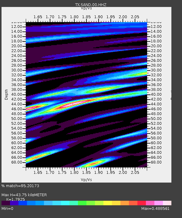
| Estimated Moho Depth: |
43.75 km |
| Estimated Crust Vp/Vs: |
1.79 |
| Assumed Crust Vp: |
6.419 km/s |
| Estimated Crust Vs: |
3.581 km/s |
| Estimated Crust Poisson's Ratio: |
0.27 |
|
| Radial Match: |
95.20173 % |
| Radial Bump: |
340 |
| Transverse Match: |
87.194016 % |
| Transverse Bump: |
400 |
| SOD ConfigId: |
29756493 |
| Insert Time: |
2022-11-25 11:26:14.635 +0000 |
| GWidth: |
2.5 |
| Max Bumps: |
400 |
| Tol: |
0.001 |
|

Signal To Noise
| Channel | StoN | STA | LTA |
| TX:SAND:00:HHZ:20221111T11:00:38.109996Z | 29.657982 | 6.3791886E-6 | 2.150918E-7 |
| TX:SAND:00:HH1:20221111T11:00:38.109996Z | 14.064732 | 1.7567256E-6 | 1.249029E-7 |
| TX:SAND:00:HH2:20221111T11:00:38.109996Z | 3.486473 | 5.310389E-7 | 1.5231407E-7 |
| Arrivals |
| Ps | 5.5 SECOND |
| PpPs | 19 SECOND |
| PsPs/PpSs | 24 SECOND |


