You are here: Home > Network List > TX - Texas Seismological Network Stations List
> Station SNAG San Augustine > Earthquake Result Viewer
SNAG San Augustine - Earthquake Result Viewer
| Earthquake location: |
Tonga Islands Region |
| Earthquake latitude/longitude: |
-19.3/-172.1 |
| Earthquake time(UTC): |
2022/11/11 (315) 10:48:45 GMT |
| Earthquake Depth: |
25 km |
| Earthquake Magnitude: |
7.3 Mww |
| Earthquake Catalog/Contributor: |
NEIC PDE/us |
|
| Network: |
TX Texas Seismological Network |
| Station: |
SNAG San Augustine |
| Lat/Lon: |
31.52 N/94.18 W |
| Elevation: |
84 m |
|
| Distance: |
90.1 deg |
| Az: |
56.629 deg |
| Baz: |
247.44 deg |
| Ray Param: |
0.04171927 |
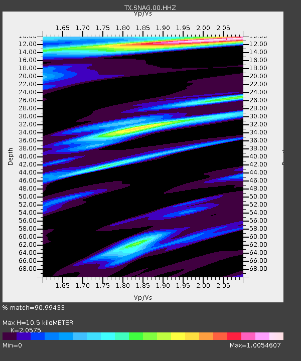
| Estimated Moho Depth: |
10.5 km |
| Estimated Crust Vp/Vs: |
2.06 |
| Assumed Crust Vp: |
5.738 km/s |
| Estimated Crust Vs: |
2.789 km/s |
| Estimated Crust Poisson's Ratio: |
0.35 |
|
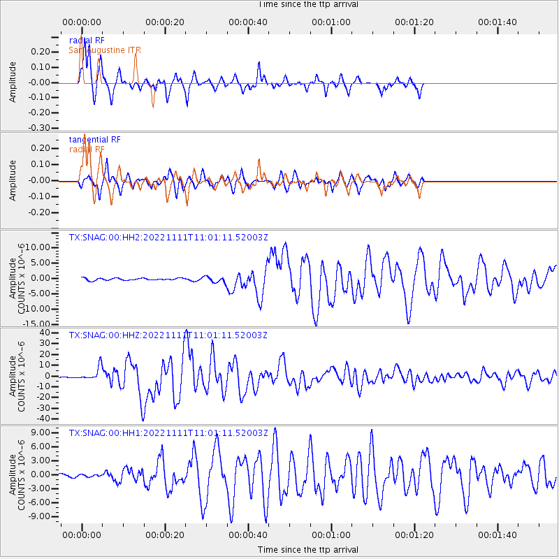
| Radial Match: |
90.99433 % |
| Radial Bump: |
274 |
| Transverse Match: |
85.30153 % |
| Transverse Bump: |
336 |
| SOD ConfigId: |
29756493 |
| Insert Time: |
2022-11-25 11:26:29.188 +0000 |
| GWidth: |
2.5 |
| Max Bumps: |
400 |
| Tol: |
0.001 |
|
Signal To Noise
| Channel | StoN | STA | LTA |
| TX:SNAG:00:HHZ:20221111T11:01:11.52003Z | 14.712242 | 6.5115096E-6 | 4.4259124E-7 |
| TX:SNAG:00:HH1:20221111T11:01:11.52003Z | 0.6126821 | 2.1955637E-7 | 3.5835282E-7 |
| TX:SNAG:00:HH2:20221111T11:01:11.52003Z | 2.6880753 | 9.3954765E-7 | 3.4952433E-7 |
| Arrivals |
| Ps | 2.0 SECOND |
| PpPs | 5.5 SECOND |
| PsPs/PpSs | 7.5 SECOND |


