You are here: Home > Network List > TX - Texas Seismological Network Stations List
> Station PB22 South of Coyonosa > Earthquake Result Viewer
PB22 South of Coyonosa - Earthquake Result Viewer
| Earthquake location: |
Tonga Islands Region |
| Earthquake latitude/longitude: |
-19.3/-172.1 |
| Earthquake time(UTC): |
2022/11/11 (315) 10:48:45 GMT |
| Earthquake Depth: |
25 km |
| Earthquake Magnitude: |
7.3 Mww |
| Earthquake Catalog/Contributor: |
NEIC PDE/us |
|
| Network: |
TX Texas Seismological Network |
| Station: |
PB22 South of Coyonosa |
| Lat/Lon: |
31.21 N/103.08 W |
| Elevation: |
808 m |
|
| Distance: |
83.1 deg |
| Az: |
53.692 deg |
| Baz: |
242.651 deg |
| Ray Param: |
0.04640013 |
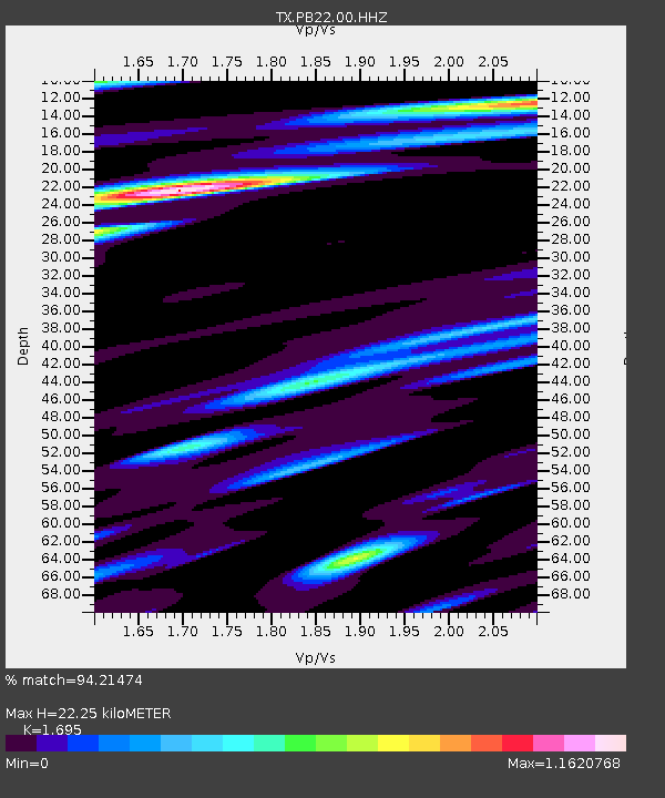
| Estimated Moho Depth: |
22.25 km |
| Estimated Crust Vp/Vs: |
1.70 |
| Assumed Crust Vp: |
6.121 km/s |
| Estimated Crust Vs: |
3.611 km/s |
| Estimated Crust Poisson's Ratio: |
0.23 |
|
| Radial Match: |
94.21474 % |
| Radial Bump: |
400 |
| Transverse Match: |
79.75268 % |
| Transverse Bump: |
400 |
| SOD ConfigId: |
29756493 |
| Insert Time: |
2022-11-25 11:26:37.035 +0000 |
| GWidth: |
2.5 |
| Max Bumps: |
400 |
| Tol: |
0.001 |
|

Signal To Noise
| Channel | StoN | STA | LTA |
| TX:PB22:00:HHZ:20221111T11:00:37.27003Z | 38.25469 | 8.676753E-7 | 2.2681542E-8 |
| TX:PB22:00:HH1:20221111T11:00:37.27003Z | 2.2538452 | 6.83743E-8 | 3.0336732E-8 |
| TX:PB22:00:HH2:20221111T11:00:37.27003Z | 2.4533644 | 5.537097E-8 | 2.2569402E-8 |
| Arrivals |
| Ps | 2.6 SECOND |
| PpPs | 9.6 SECOND |
| PsPs/PpSs | 12 SECOND |


