You are here: Home > Network List > UO - University of Oregon Regional Network Stations List
> Station DFAZ Toketee, OR, USA > Earthquake Result Viewer
DFAZ Toketee, OR, USA - Earthquake Result Viewer
| Earthquake location: |
Tonga Islands Region |
| Earthquake latitude/longitude: |
-19.3/-172.1 |
| Earthquake time(UTC): |
2022/11/11 (315) 10:48:45 GMT |
| Earthquake Depth: |
25 km |
| Earthquake Magnitude: |
7.3 Mww |
| Earthquake Catalog/Contributor: |
NEIC PDE/us |
|
| Network: |
UO University of Oregon Regional Network |
| Station: |
DFAZ Toketee, OR, USA |
| Lat/Lon: |
43.24 N/122.11 W |
| Elevation: |
1948 m |
|
| Distance: |
77.3 deg |
| Az: |
35.008 deg |
| Baz: |
227.849 deg |
| Ray Param: |
0.050362926 |
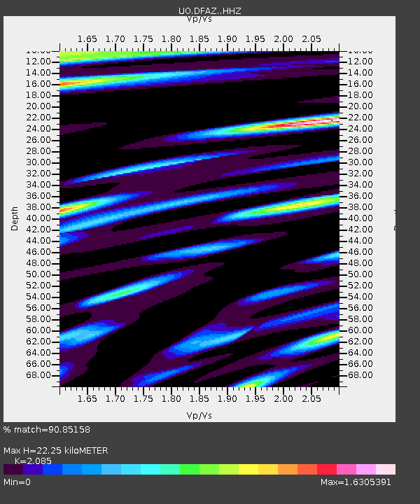
| Estimated Moho Depth: |
22.25 km |
| Estimated Crust Vp/Vs: |
2.09 |
| Assumed Crust Vp: |
6.522 km/s |
| Estimated Crust Vs: |
3.128 km/s |
| Estimated Crust Poisson's Ratio: |
0.35 |
|
| Radial Match: |
90.85158 % |
| Radial Bump: |
400 |
| Transverse Match: |
84.11842 % |
| Transverse Bump: |
400 |
| SOD ConfigId: |
29756493 |
| Insert Time: |
2022-11-25 11:26:48.922 +0000 |
| GWidth: |
2.5 |
| Max Bumps: |
400 |
| Tol: |
0.001 |
|

Signal To Noise
| Channel | StoN | STA | LTA |
| UO:DFAZ: :HHZ:20221111T11:00:06.338023Z | 30.996162 | 8.659856E-6 | 2.7938478E-7 |
| UO:DFAZ: :HHN:20221111T11:00:06.338023Z | 5.8375764 | 1.8007645E-6 | 3.084781E-7 |
| UO:DFAZ: :HHE:20221111T11:00:06.338023Z | 8.320793 | 2.4805652E-6 | 2.9811645E-7 |
| Arrivals |
| Ps | 3.8 SECOND |
| PpPs | 10 SECOND |
| PsPs/PpSs | 14 SECOND |


