You are here: Home > Network List > UO - University of Oregon Regional Network Stations List
> Station DRAN Drain, OR, USA > Earthquake Result Viewer
DRAN Drain, OR, USA - Earthquake Result Viewer
| Earthquake location: |
Tonga Islands Region |
| Earthquake latitude/longitude: |
-19.3/-172.1 |
| Earthquake time(UTC): |
2022/11/11 (315) 10:48:45 GMT |
| Earthquake Depth: |
25 km |
| Earthquake Magnitude: |
7.3 Mww |
| Earthquake Catalog/Contributor: |
NEIC PDE/us |
|
| Network: |
UO University of Oregon Regional Network |
| Station: |
DRAN Drain, OR, USA |
| Lat/Lon: |
43.70 N/123.35 W |
| Elevation: |
141 m |
|
| Distance: |
77.0 deg |
| Az: |
34.036 deg |
| Baz: |
226.783 deg |
| Ray Param: |
0.0506017 |
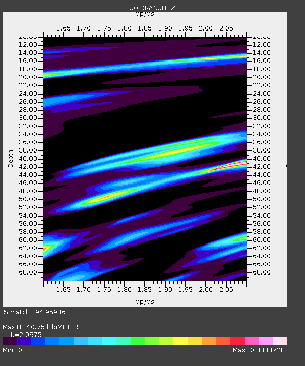
| Estimated Moho Depth: |
40.75 km |
| Estimated Crust Vp/Vs: |
2.10 |
| Assumed Crust Vp: |
6.522 km/s |
| Estimated Crust Vs: |
3.109 km/s |
| Estimated Crust Poisson's Ratio: |
0.35 |
|
| Radial Match: |
94.95986 % |
| Radial Bump: |
289 |
| Transverse Match: |
90.52193 % |
| Transverse Bump: |
400 |
| SOD ConfigId: |
29756493 |
| Insert Time: |
2022-11-25 11:26:52.155 +0000 |
| GWidth: |
2.5 |
| Max Bumps: |
400 |
| Tol: |
0.001 |
|

Signal To Noise
| Channel | StoN | STA | LTA |
| UO:DRAN: :HHZ:20221111T11:00:04.359996Z | 36.305912 | 6.9553817E-6 | 1.9157712E-7 |
| UO:DRAN: :HHN:20221111T11:00:04.359996Z | 9.94875 | 1.8300639E-6 | 1.8394913E-7 |
| UO:DRAN: :HHE:20221111T11:00:04.359996Z | 9.899783 | 2.0420039E-6 | 2.0626754E-7 |
| Arrivals |
| Ps | 7.0 SECOND |
| PpPs | 19 SECOND |
| PsPs/PpSs | 26 SECOND |


