You are here: Home > Network List > TA - USArray Transportable Network (new EarthScope stations) Stations List
> Station 633A Saathoff Ranch, Hondo, TX, USA > Earthquake Result Viewer
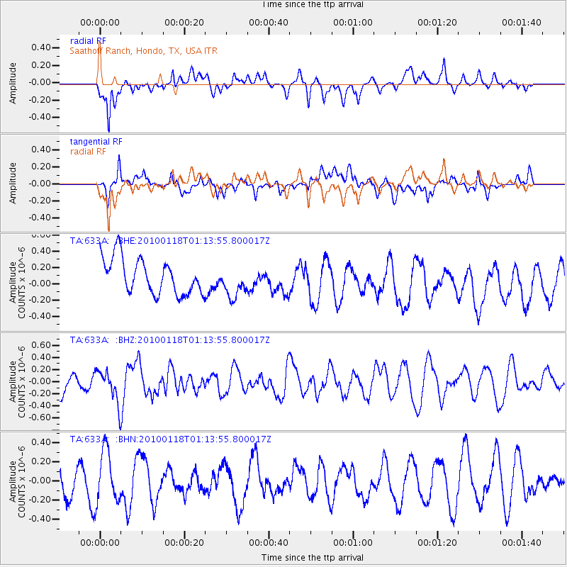
633A Saathoff Ranch, Hondo, TX, USA - Earthquake Result Viewer
*The percent match for this event was below the threshold and hence no stack was calculated.
| Earthquake location: |
Kuril Islands |
| Earthquake latitude/longitude: |
46.5/153.3 |
| Earthquake time(UTC): |
2010/01/18 (018) 01:02:16 GMT |
| Earthquake Depth: |
7.0 km |
| Earthquake Magnitude: |
5.6 MB, 5.3 MS, 5.6 MW, 5.6 MW |
| Earthquake Catalog/Contributor: |
WHDF/NEIC |
|
| Network: |
TA USArray Transportable Network (new EarthScope stations) |
| Station: |
633A Saathoff Ranch, Hondo, TX, USA |
| Lat/Lon: |
29.46 N/99.18 W |
| Elevation: |
320 m |
|
| Distance: |
80.1 deg |
| Az: |
57.568 deg |
| Baz: |
318.029 deg |
| Ray Param: |
$rayparam |
*The percent match for this event was below the threshold and hence was not used in the summary stack. |
|
| Radial Match: |
50.82688 % |
| Radial Bump: |
400 |
| Transverse Match: |
62.733604 % |
| Transverse Bump: |
400 |
| SOD ConfigId: |
296938 |
| Insert Time: |
2010-04-06 21:18:51.835 +0000 |
| GWidth: |
2.5 |
| Max Bumps: |
400 |
| Tol: |
0.001 |
|
Signal To Noise
| Channel | StoN | STA | LTA |
| TA:633A: :BHZ:20100118T01:13:55.800017Z | 1.1802442 | 2.6600588E-7 | 2.2538207E-7 |
| TA:633A: :BHN:20100118T01:13:55.800017Z | 1.2311618 | 2.6637034E-7 | 2.1635688E-7 |
| TA:633A: :BHE:20100118T01:13:55.800017Z | 0.9251221 | 1.9965927E-7 | 2.1581938E-7 |
| Arrivals |
| Ps | |
| PpPs | |
| PsPs/PpSs | |


