You are here: Home > Network List > UO - University of Oregon Regional Network Stations List
> Station SALT Butte Falls, OR, USA > Earthquake Result Viewer
SALT Butte Falls, OR, USA - Earthquake Result Viewer
| Earthquake location: |
Tonga Islands Region |
| Earthquake latitude/longitude: |
-19.3/-172.1 |
| Earthquake time(UTC): |
2022/11/11 (315) 10:48:45 GMT |
| Earthquake Depth: |
25 km |
| Earthquake Magnitude: |
7.3 Mww |
| Earthquake Catalog/Contributor: |
NEIC PDE/us |
|
| Network: |
UO University of Oregon Regional Network |
| Station: |
SALT Butte Falls, OR, USA |
| Lat/Lon: |
42.49 N/122.59 W |
| Elevation: |
1179 m |
|
| Distance: |
76.6 deg |
| Az: |
35.332 deg |
| Baz: |
227.597 deg |
| Ray Param: |
0.050881494 |
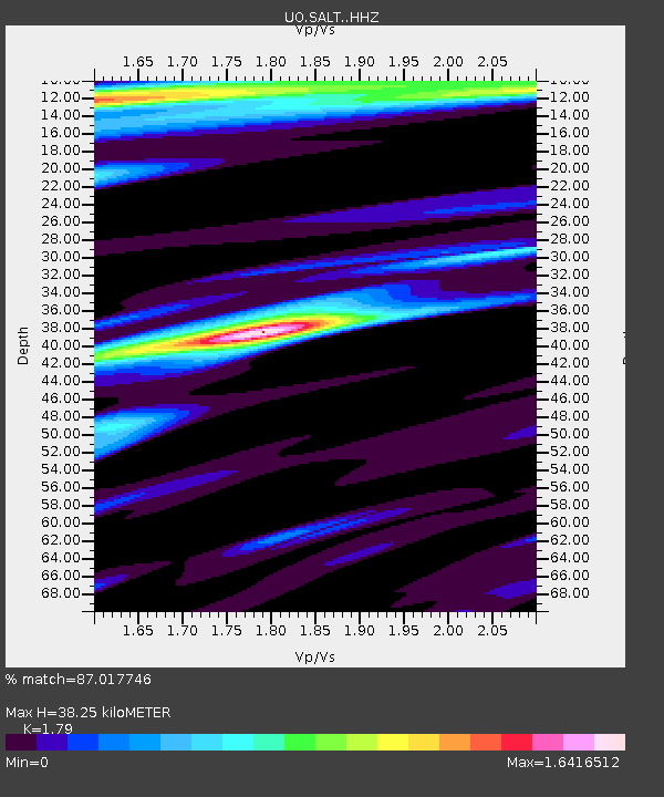
| Estimated Moho Depth: |
38.25 km |
| Estimated Crust Vp/Vs: |
1.79 |
| Assumed Crust Vp: |
6.522 km/s |
| Estimated Crust Vs: |
3.643 km/s |
| Estimated Crust Poisson's Ratio: |
0.27 |
|
| Radial Match: |
87.017746 % |
| Radial Bump: |
400 |
| Transverse Match: |
78.82841 % |
| Transverse Bump: |
400 |
| SOD ConfigId: |
29756493 |
| Insert Time: |
2022-11-25 11:27:37.753 +0000 |
| GWidth: |
2.5 |
| Max Bumps: |
400 |
| Tol: |
0.001 |
|

Signal To Noise
| Channel | StoN | STA | LTA |
| UO:SALT: :HHZ:20221111T11:00:02.060008Z | 51.313545 | 8.10762E-6 | 1.5800155E-7 |
| UO:SALT: :HHN:20221111T11:00:02.060008Z | 7.3305054 | 1.2964383E-6 | 1.7685524E-7 |
| UO:SALT: :HHE:20221111T11:00:02.060008Z | 4.628365 | 1.3358748E-6 | 2.8862777E-7 |
| Arrivals |
| Ps | 4.8 SECOND |
| PpPs | 16 SECOND |
| PsPs/PpSs | 21 SECOND |


