You are here: Home > Network List > UO - University of Oregon Regional Network Stations List
> Station TDWTR Tidewater, OR, USA > Earthquake Result Viewer
TDWTR Tidewater, OR, USA - Earthquake Result Viewer
| Earthquake location: |
Tonga Islands Region |
| Earthquake latitude/longitude: |
-19.3/-172.1 |
| Earthquake time(UTC): |
2022/11/11 (315) 10:48:45 GMT |
| Earthquake Depth: |
25 km |
| Earthquake Magnitude: |
7.3 Mww |
| Earthquake Catalog/Contributor: |
NEIC PDE/us |
|
| Network: |
UO University of Oregon Regional Network |
| Station: |
TDWTR Tidewater, OR, USA |
| Lat/Lon: |
44.35 N/123.89 W |
| Elevation: |
594 m |
|
| Distance: |
77.1 deg |
| Az: |
33.277 deg |
| Baz: |
226.241 deg |
| Ray Param: |
0.050489496 |
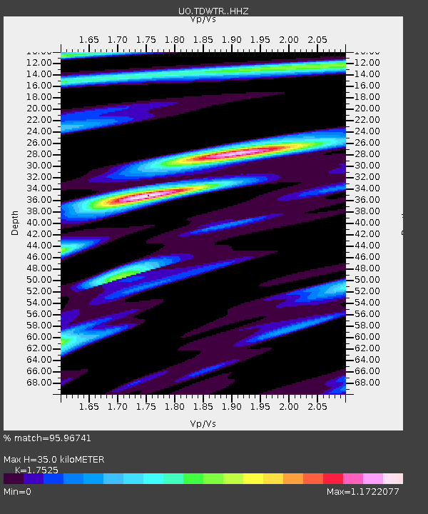
| Estimated Moho Depth: |
35.0 km |
| Estimated Crust Vp/Vs: |
1.75 |
| Assumed Crust Vp: |
6.566 km/s |
| Estimated Crust Vs: |
3.747 km/s |
| Estimated Crust Poisson's Ratio: |
0.26 |
|
| Radial Match: |
95.96741 % |
| Radial Bump: |
389 |
| Transverse Match: |
86.44044 % |
| Transverse Bump: |
400 |
| SOD ConfigId: |
29756493 |
| Insert Time: |
2022-11-25 11:28:04.989 +0000 |
| GWidth: |
2.5 |
| Max Bumps: |
400 |
| Tol: |
0.001 |
|

Signal To Noise
| Channel | StoN | STA | LTA |
| UO:TDWTR: :HHZ:20221111T11:00:05.289988Z | 28.971365 | 8.410834E-6 | 2.9031543E-7 |
| UO:TDWTR: :HHN:20221111T11:00:05.289988Z | 8.598968 | 2.497793E-6 | 2.9047592E-7 |
| UO:TDWTR: :HHE:20221111T11:00:05.289988Z | 8.024678 | 2.776278E-6 | 3.4596752E-7 |
| Arrivals |
| Ps | 4.1 SECOND |
| PpPs | 14 SECOND |
| PsPs/PpSs | 18 SECOND |


