You are here: Home > Network List > UO - University of Oregon Regional Network Stations List
> Station LONE Glide, OR, USA > Earthquake Result Viewer
LONE Glide, OR, USA - Earthquake Result Viewer
| Earthquake location: |
Tonga Islands Region |
| Earthquake latitude/longitude: |
-19.3/-172.1 |
| Earthquake time(UTC): |
2022/11/11 (315) 10:48:45 GMT |
| Earthquake Depth: |
25 km |
| Earthquake Magnitude: |
7.3 Mww |
| Earthquake Catalog/Contributor: |
NEIC PDE/us |
|
| Network: |
UO University of Oregon Regional Network |
| Station: |
LONE Glide, OR, USA |
| Lat/Lon: |
43.36 N/123.06 W |
| Elevation: |
1226 m |
|
| Distance: |
76.9 deg |
| Az: |
34.435 deg |
| Baz: |
227.073 deg |
| Ray Param: |
0.050649356 |
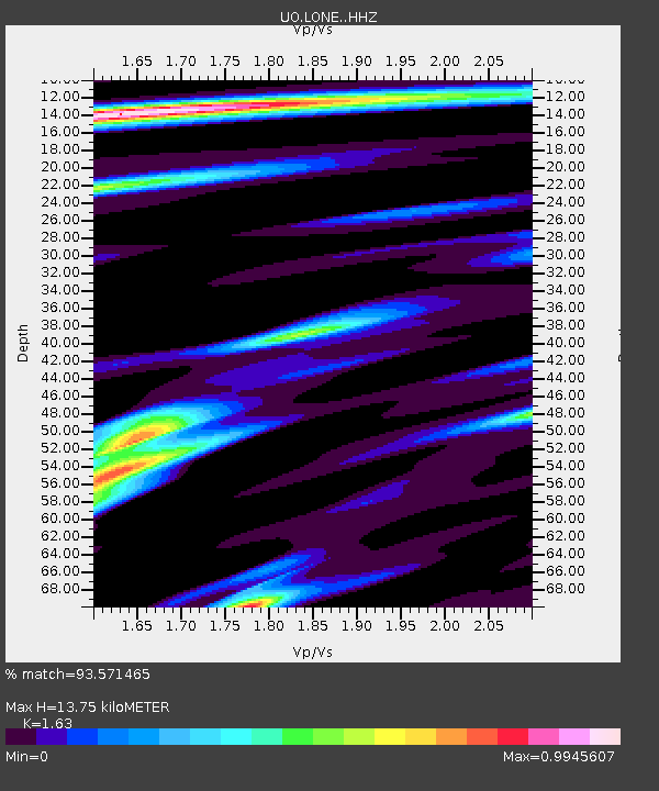
| Estimated Moho Depth: |
13.75 km |
| Estimated Crust Vp/Vs: |
1.63 |
| Assumed Crust Vp: |
6.522 km/s |
| Estimated Crust Vs: |
4.001 km/s |
| Estimated Crust Poisson's Ratio: |
0.20 |
|
| Radial Match: |
93.571465 % |
| Radial Bump: |
266 |
| Transverse Match: |
86.30348 % |
| Transverse Bump: |
400 |
| SOD ConfigId: |
29756493 |
| Insert Time: |
2022-11-25 11:28:08.756 +0000 |
| GWidth: |
2.5 |
| Max Bumps: |
400 |
| Tol: |
0.001 |
|

Signal To Noise
| Channel | StoN | STA | LTA |
| UO:LONE: :HHZ:20221111T11:00:03.950022Z | 28.784727 | 8.06195E-6 | 2.8007736E-7 |
| UO:LONE: :HHN:20221111T11:00:03.950022Z | 4.9975724 | 1.7488352E-6 | 3.4993693E-7 |
| UO:LONE: :HHE:20221111T11:00:03.950022Z | 12.50714 | 2.6399698E-6 | 2.1107702E-7 |
| Arrivals |
| Ps | 1.4 SECOND |
| PpPs | 5.4 SECOND |
| PsPs/PpSs | 6.7 SECOND |


